Plantation, FL Hail Storm – July 2025
July 12, 2025 hail storm near Plantation, FL. Radar-confirmed hail track and contractor lead lists available.
Max Hail
1.75"1" est.
confirmed
Zones
3
NWS alerts
Radar
64
dual-pol hits
Spotter
2
field reports
NWS WARNING AREA · Plantation Metro · Jul 12, 2025
Intelligence Platform
StormSnipe Pro
$49/ mo
Cancel anytime · No contracts
›All 50 states
›No zone limits
›No per-event fees
Subscribe to Pro
Pro renews monthly until canceled · Cancel anytime in the billing portal
What's included
Instant delivery
Every storm published within hours of NOAA confirmation.
Interactive Strike Map
Full radar-confirmed hail track on an interactive map.
Address CSV export
Every affected residential address, export-ready.
Smart alerts
Notified when a storm hits your area. Set zones once.
Nationwide coverage
All 50 states. No zone restrictions. No geographic caps.
Live pipeline
NOAA NEXRAD processed and delivered 24/7.
Address data notice
Pro coverage in California, Vermont, and Oregon includes the confirmed hail track and Strike Map only — no address lists. State data-privacy law treats compiled address lists differently in those three states, so we exclude their addresses from extraction and delivery.
NWS WARNING AREAS · 3
This storm generated 3 NWS alert zones. Pro access covers the complete storm track and all addresses across every zone.
ZONE 1NWS MFL
Plantation, FL
Dual-Pol Radar
Alert issued Sat, Jul 12 · 6:26 PM UTC
1.75"
confirmed
1"
est. (NWS)
ZONE 2NWS MFL
Coral Springs, FL
Dual-Pol Radar
Alert issued Sat, Jul 12 · 6:56 PM UTC
1.75"
confirmed
1"
est. (NWS)
ZONE 3NWS MFL
West Palm Beach, FL
Dual-Pol Radar
Alert issued Sat, Jul 12 · 7:56 PM UTC
1.75"
confirmed
1"
est. (NWS)
What Happened
A hail storm moved through Plantation, FL on July 12, 2025, with verified 1-inch stones and multiple alert cycles through the afternoon. Field reports placed the strongest hail around NW 27th Street and Inverrary Boulevard at 2:40 PM EDT, followed by another report near Coral Spring Nissan and the Stranahan River at 3:00 PM EDT.
The first NWS alert came at 2:26 PM EDT with 1-inch hail tied to radar and spotter verification. A second alert followed at 2:56 PM EDT with the same hail size and the same verification level. A later alert at 3:56 PM EDT again carried a 1-inch hail estimate, this time from dual-polarization radar, with confidence from NEXRAD hail detection.
The field reports fit a short window of repeated hail cores moving across the Plantation metro area. The first report came in from a spotter near NW 27th Street and Inverrary Boulevard, who reported stones up to 1 inch in size. Twenty minutes later, a public report noted nickel to quarter size hail with street flooding near Coral Spring Nissan and the Stranahan River.
Damage Assessment
The storm left a narrow but documented hail footprint across parts of Plantation. The reported stones were large enough to reach 1-inch size in two separate observations, with the second report pairing hail with street flooding near a commercial corridor and the Stranahan River.
The most useful ground truth comes from the two local reports. Near NW 27th Street and Inverrary Boulevard, the spotter report pinned down the first verified hail size. Near Coral Spring Nissan, the public report described smaller hail mixed with flooding on the streets. That combination points to brief but forceful convective bursts rather than a long-duration hail episode.
Radar support was consistent with the field reports. The 2:26 PM and 2:56 PM alerts carried radar and spotter-verified confidence. The 3:56 PM alert added dual-polarization radar support. Together, the reports show a storm that stayed organized enough to generate repeated hail confirmation during the afternoon.
For roof and vehicle checks, the most relevant addresses are the places named in the reports and the surrounding blocks in the storm path. A spotter-confirmed 1-inch hail report near NW 27th Street and Inverrary Boulevard places the first impact area in a residential and arterial road mix. The later report near Coral Spring Nissan points to exposure along a commercial strip with traffic and surface-water runoff.
What Contractors Should Know
This event concentrated hail into a short afternoon window. Crews working Plantation on July 12 should focus on properties near NW 27th Street, Inverrary Boulevard, and the Coral Spring Nissan area first. Those locations sit inside the documented report corridor and are the strongest candidates for inspection requests tied to the storm.
Storm Details
- Start Date
- Saturday, July 12, 2025
- Last Activity
- Saturday, July 12, 2025
- Location
- Plantation, FL
- Warning Areas
- 3
- Dual-Pol Radar
- 64
- Spotter Reports
- 2
Preview Strike Map
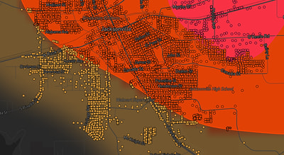
See exactly what you get.
Explore the full Springdale, AR Strike Map free – hail track, address overlay, and CSV download. No account required.
Try the Free Demo →