Bay City, TX Hail Storm – August 2025
August 21, 2025 hail storm near Bay City, TX. Radar-confirmed hail track and contractor lead lists available.
Max Hail
1.75"1" est.
confirmed
Zones
1
NWS alerts
Radar
21
dual-pol hits
Spotter
–
field reports
NWS WARNING AREA · Bay City Metro · Aug 21, 2025
Intelligence Platform
StormSnipe Pro
$49/ mo
Cancel anytime · No contracts
›All 50 states
›No zone limits
›No per-event fees
Subscribe to Pro
Pro renews monthly until canceled · Cancel anytime in the billing portal
What's included
Instant delivery
Every storm published within hours of NOAA confirmation.
Interactive Strike Map
Full radar-confirmed hail track on an interactive map.
Address CSV export
Every affected residential address, export-ready.
Smart alerts
Notified when a storm hits your area. Set zones once.
Nationwide coverage
All 50 states. No zone restrictions. No geographic caps.
Live pipeline
NOAA NEXRAD processed and delivered 24/7.
Address data notice
Pro coverage in California, Vermont, and Oregon includes the confirmed hail track and Strike Map only — no address lists. State data-privacy law treats compiled address lists differently in those three states, so we exclude their addresses from extraction and delivery.
NWS WARNING AREA
NWS HGX
Bay City, TX
Dual-Pol Radar
5,030 addresses in warning area
Alert issued Thu, Aug 21 · 10:36 PM UTC
1.75"
confirmed
1"
est. (NWS)
Bay City, TX saw a single-zone hail storm on August 21, 2025, with a confirmed peak hail size of 1 inch. The storm concluded after a late-afternoon warning area covered the city.
What Happened
A severe thunderstorm warning was issued at 5:36 PM CDT on August 21, 2025, for hail up to 1 inch in Bay City. Dual-polarization radar supported the hail detection with high confidence. The event remained focused on one storm zone and did not expand into multiple confirmed hail corridors.
The warning arrived in the early evening window, when storms in coastal Texas often organize quickly and move through a city without a long lead time. In this case, the hail signal stayed centered on Bay City and matched a brief severe hail episode rather than a prolonged multicell event.
No additional confirmed hail size above 1 inch was reported for this storm. The hail reached severe criteria, but the footprint stayed limited to a single tracked area across the city.
Damage Assessment
One-inch hail can damage roof coverings, gutters, soft metals, and exposed vehicle surfaces. Asphalt shingles may show fresh bruising or granule loss, especially on older roofs or areas already worn by heat and wind. Metal fascia, vent caps, and AC fins can also show impact marks after a hail hit of this size.
On homes and commercial properties, the most useful field check is a focused exterior walk after the storm. Look for dents on roof accessories, chipped paint on trim, and impact marks on windowsills, siding, and equipment housings. Vehicles parked in the open are also at risk, with light body dents and broken or pitted surfaces possible from 1-inch hail.
In Bay City, a hail event of this size is usually enough to justify close inspection of roof edges, penetrations, and flat sections where debris may collect. Contractors should expect damage to vary by material, roof age, and direct exposure within the warning area.
What Contractors Should Know
Start with the properties nearest the heaviest hail signal, then move outward through the rest of the warning area. Focus on roof slopes, ridge lines, pipe boots, vents, skylight frames, and soft metal components. On low-slope roofs, check drains, seams, and parapet edges for impact marks and displaced granules. On steep-slope systems, document bruising, lifted tabs, cracked sealant, and broken accessories.
Exterior signs matter before anyone opens the interior. Photograph gutters, downspouts, condensers, window screens, fence caps, and vehicle panels. If a site has mixed roof types, inspect each material separately. Metal systems, composition shingles, modified bitumen, and tile each show hail differently after a 1-inch event.
For estimates and canvassing, keep the scope tied to the city’s actual hail size and the confirmed warning area. Bay City did not see a broad hail swath in this report, so field crews should treat claims as localized until roof-level evidence confirms otherwise.
Storm Details
- Start Date
- Thursday, August 21, 2025
- Last Activity
- Thursday, August 21, 2025
- Location
- Bay City, TX
- Warning Areas
- 1
- Dual-Pol Radar
- 21
- Spotter Reports
- --
Preview Strike Map
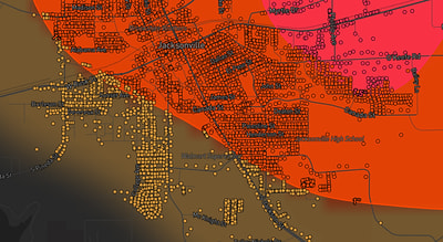
See exactly what you get.
Explore the full Springdale, AR Strike Map free – hail track, address overlay, and CSV download. No account required.
Try the Free Demo →