Bosque, NM Hail Storm – October 2025
October 7, 2025 hail storm near Bosque, NM. Radar-confirmed hail track and contractor lead lists available.
Max Hail
4"2.5" est.
confirmed
Zones
9
NWS alerts
Radar
236
dual-pol hits
Spotter
15
field reports
NWS WARNING AREA · Bosque Metro · Oct 7, 2025
Intelligence Platform
StormSnipe Pro
$49/ mo
Cancel anytime · No contracts
›All 50 states
›No zone limits
›No per-event fees
Subscribe to Pro
Pro renews monthly until canceled · Cancel anytime in the billing portal
What's included
Instant delivery
Every storm published within hours of NOAA confirmation.
Interactive Strike Map
Full radar-confirmed hail track on an interactive map.
Address CSV export
Every affected residential address, export-ready.
Smart alerts
Notified when a storm hits your area. Set zones once.
Nationwide coverage
All 50 states. No zone restrictions. No geographic caps.
Live pipeline
NOAA NEXRAD processed and delivered 24/7.
Address data notice
Pro coverage in California, Vermont, and Oregon includes the confirmed hail track and Strike Map only — no address lists. State data-privacy law treats compiled address lists differently in those three states, so we exclude their addresses from extraction and delivery.
NWS WARNING AREAS · 9
This storm generated 9 NWS alert zones. Pro access covers the complete storm track and all addresses across every zone.
ZONE 1NWS ABQ
Bosque, NM
Dual-Pol Radar
21 addresses in warning area
Alert issued Tue, Oct 7 · 9:40 PM UTC
3.75"
confirmed
2.5"
est. (NWS)
ZONE 2NWS ABQ
Bosque, NM
Dual-Pol Radar
Alert issued Tue, Oct 7 · 9:59 PM UTC
3.75"
confirmed
1"
est. (NWS)
ZONE 3NWS ABQ
Magdalena, NM
Dual-Pol Radar
152 addresses in warning area
Alert issued Tue, Oct 7 · 10:05 PM UTC
1.75"
confirmed
1"
est. (NWS)
ZONE 4NWS ABQ
Bosque, NM
Dual-Pol Radar
911 addresses in warning area
Alert issued Tue, Oct 7 · 10:26 PM UTC
3.75"
confirmed
2.5"
est. (NWS)
ZONE 5NWS ABQ
Bosque, NM
Dual-Pol Radar
Alert issued Tue, Oct 7 · 10:41 PM UTC
3.75"
confirmed
1.5"
est. (NWS)
ZONE 6NWS ABQ
Veguita, NM
Dual-Pol Radar
29 addresses in warning area
Alert issued Tue, Oct 7 · 11:14 PM UTC
4"
confirmed
1.75"
est. (NWS)
ZONE 7NWS ABQ
Bosque, NM
Dual-Pol Radar
Alert issued Tue, Oct 7 · 11:24 PM UTC
1.75"
confirmed
1"
est. (NWS)
ZONE 8NWS ABQ
Mountainair, NM
Dual-Pol Radar
63 addresses in warning area
Alert issued Tue, Oct 7 · 11:51 PM UTC
4"
confirmed
1.75"
est. (NWS)
ZONE 9NWS ABQ
San Antonio, NM
Dual-Pol Radar
2 addresses in warning area
Alert issued Wed, Oct 8 · 12:49 AM UTC
2.5"
confirmed
1"
est. (NWS)
What Happened
A severe hail storm moved through Bosque, NM, on October 7, 2025, with peak hail reaching 2.5 inches. The storm produced nine NWS hail alerts from 3:40 PM MDT through 6:49 PM MDT, with the strongest detections clustered from mid-afternoon into early evening.
The first alert came at 3:40 PM MDT and carried a 2.5-inch hail estimate from dual-polarization radar. By 3:59 PM MDT and 4:05 PM MDT, radar and spotter verification supported 1-inch hail. At 4:26 PM MDT, another alert again reached 2.5 inches. The system remained active through late afternoon, with alerts for 1.5-inch hail at 4:41 PM MDT, 1.75-inch hail at 5:14 PM MDT and 5:51 PM MDT, and 1-inch hail at 5:24 PM MDT and 6:49 PM MDT.
Field reports placed hail on the ground in the same window. At 4:08 PM MDT, a spotter report from NM169 at MM28 confirmed 1-inch hail. Later, at 6:41 PM MDT, an mPING report again documented quarter-sized hail at 1.00 inch. The storm also produced water over roadways as the hail and rain moved through the area. At 5:50 PM MDT, water covered I-25 northbound at mile marker 178 and blocked one lane. At 6:10 PM MDT, water was flowing across Hwy 116 with debris in the water.
The report sequence shows a long-lived hail core with repeated output through the late afternoon and evening. Radar estimates and spotter checks both supported the hail threat across Bosque during the event.
Damage Assessment
The field reports point to a storm that did more than drop hail. Water covering I-25 northbound at mile marker 178 forced a lane closure, and runoff crossed Hwy 116 with debris carried in the flow. Those reports came from separate points in the storm track and show roadway impacts tied to the same hail and rain episode.
Spotter-confirmed 1-inch hail at NM169 at MM28 and again through mPING at 6:41 PM MDT gives a clear ground check on the smaller hail footprint. The radar-detected 1.75-inch and 2.5-inch estimates earlier in the day suggest stronger cores within the broader warning area, but the confirmed surface reports in Bosque centered on one-inch hail and local flooding issues rather than widespread structural damage in the available field notes.
Contractors should read this event as a multi-pass hail track with repeated impacts rather than a single brief burst. That means multiple inspection windows across the afternoon and evening, not one isolated callout. Roof, screen, gutter, soft-metal, and vehicle checks remain the usual first pass after an event like this, but the local reports also support a review of drainage points, culverts, and low crossings where water accumulated.
What Contractors Should Know
Bosque, NM, saw hail reports spread across several hours, with verified surface impacts at NM169, I-25 northbound at MM 178, and Hwy 116. Crews working this area should expect scattered timing differences inside the broader warning area. Some addresses likely took hail early, while others saw the strongest rain and runoff later in the storm cycle.
Storm Details
- Start Date
- Tuesday, October 7, 2025
- Last Activity
- Tuesday, October 7, 2025
- Location
- Bosque, NM
- Warning Areas
- 9
- Dual-Pol Radar
- 236
- Spotter Reports
- 15
Preview Strike Map
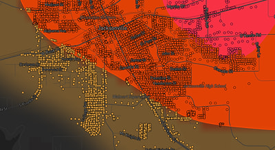
See exactly what you get.
Explore the full Springdale, AR Strike Map free – hail track, address overlay, and CSV download. No account required.
Try the Free Demo →