Bay City, TX Hail Storm – October 2025
October 26, 2025 hail storm near Bay City, TX. Radar-confirmed hail track and contractor lead lists available.
Max Hail
2.25"1" est.
confirmed
Zones
1
NWS alerts
Radar
16
dual-pol hits
Spotter
–
field reports
NWS WARNING AREA · Bay City Metro · Oct 26, 2025
Intelligence Platform
StormSnipe Pro
$49/ mo
Cancel anytime · No contracts
›All 50 states
›No zone limits
›No per-event fees
Subscribe to Pro
Pro renews monthly until canceled · Cancel anytime in the billing portal
What's included
Instant delivery
Every storm published within hours of NOAA confirmation.
Interactive Strike Map
Full radar-confirmed hail track on an interactive map.
Address CSV export
Every affected residential address, export-ready.
Smart alerts
Notified when a storm hits your area. Set zones once.
Nationwide coverage
All 50 states. No zone restrictions. No geographic caps.
Live pipeline
NOAA NEXRAD processed and delivered 24/7.
Address data notice
Pro coverage in California, Vermont, and Oregon includes the confirmed hail track and Strike Map only — no address lists. State data-privacy law treats compiled address lists differently in those three states, so we exclude their addresses from extraction and delivery.
NWS WARNING AREA
NWS HGX
Bay City, TX
Dual-Pol Radar
3,765 addresses in warning area
Alert issued Sun, Oct 26 · 3:54 AM UTC
2.25"
confirmed
1"
est. (NWS)
Bay City, TX saw a concluded hail event on 2025-10-26 with a peak confirmed hail size of 1 inch. The storm was tied to a single NWS warning area late that night.
What Happened
The alert for Bay City came at 10:54 PM CDT, with dual-polarization radar confidence pointing to 1-inch hail in the warning area. The storm was not a broad multi-round complex. It was a single-zone event with one alert tied to the hail report.
Radar placement kept the hail threat focused late in the evening. No additional alert in this event expanded the footprint beyond the original warning area. The weather signal remained centered on hail, not a prolonged wind or tornado setup.
The timing matters for field checks. Roof and vehicle exposure was already reduced for many properties by late evening, but parked cars, covered equipment, and unprotected roofing still remained exposed during the warning window. The storm has concluded.
Damage Assessment
One-inch hail can leave visible marks on softer roof materials, gutters, siding, vents, and exposed trim. It often produces scattered impacts rather than uniform loss. On asphalt roofs, the most common signs are bruising, granule displacement, and a limited number of direct strike points.
Metal surfaces may show denting, especially on flashings, downspouts, condensers, and vehicle panels. Shingle systems with prior wear can show stronger effects than newer roofs under the same hail size. Field crews should expect variation block to block, with some properties showing little more than minor cosmetic impact and others showing concentrated wear on slopes facing the storm path.
Tree and landscape impact is usually light at this size, though thin foliage and tender plants can still show torn leaves or stem damage. Outdoor HVAC units, skylights, and screens should be checked where the hail hit was most direct. In a single-zone event like this, damage can narrow sharply across short distances.
What Contractors Should Know
Start with the roofline and the exterior test points that fail first under 1-inch hail. Check soft metals, ridge caps, pipe boots, window screens, vents, and the north and west exposures if the storm approached from the south or southeast. Document granule loss, fractured seals, and dent patterns with close photos and wide context shots.
For canvass work, keep the scope tight. Focus on properties inside the warning area and on addresses with exposed roofs, older shingles, or prior repair history. Ask for timestamps from owners who heard hail around the warning period, and pair those reports with visible impact evidence. Vehicles parked outside during the event may provide the cleanest hail confirmation when roof marks are light.
Schedule inspections in daylight if possible. Late-night hail events often leave little immediate visibility, and wet roofing can hide impact patterns until surfaces dry. If the property is occupied, note attic leak staining, soft-surface wear, and any affected exterior equipment during the first visit.
Storm Details
- Start Date
- Saturday, October 25, 2025
- Last Activity
- Saturday, October 25, 2025
- Location
- Bay City, TX
- Warning Areas
- 1
- Dual-Pol Radar
- 16
- Spotter Reports
- --
Preview Strike Map
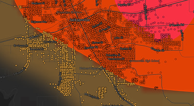
See exactly what you get.
Explore the full Springdale, AR Strike Map free – hail track, address overlay, and CSV download. No account required.
Try the Free Demo →