Maricopa, AZ Hail Storm – August 2026
August 13, 2026 hail storm near Maricopa, AZ. Radar-confirmed hail track and contractor lead lists available.
Max Hail
1.22"0.75" est.
confirmed
Zones
3
NWS alerts
Radar
6
dual-pol hits
Spotter
–
field reports
NWS WARNING AREA · Maricopa Metro · Aug 13, 2026
Intelligence Platform
StormSnipe Pro
$49/ mo
Cancel anytime · No contracts
›All 50 states
›No zone limits
›No per-event fees
Subscribe to Pro
Pro renews monthly until canceled · Cancel anytime in the billing portal
What's included
Instant delivery
Every storm published within hours of NOAA confirmation.
Interactive Strike Map
Full radar-confirmed hail track on an interactive map.
Address CSV export
Every affected residential address, export-ready.
Smart alerts
Notified when a storm hits your area. Set zones once.
Nationwide coverage
All 50 states. No zone restrictions. No geographic caps.
Live pipeline
NOAA NEXRAD processed and delivered 24/7.
Address data notice
Pro coverage in California, Vermont, and Oregon includes the confirmed hail track and Strike Map only — no address lists. State data-privacy law treats compiled address lists differently in those three states, so we exclude their addresses from extraction and delivery.
NWS WARNING AREAS · 3
This storm generated 3 NWS alert zones. Pro access covers the complete storm track and all addresses across every zone.
ZONE 1NWS AZC013
Maricopa, AZ
Dual-Pol Radar
7 addresses in warning area
Alert issued Thu, Aug 13 · 11:24 PM UTC
1.5"
confirmed
0.75"
est. (NWS)
ZONE 2NWS AZC013
Laveen, AZ
Dual-Pol Radar
Alert issued Fri, Aug 14 · 12:06 AM UTC
1.5"
confirmed
0.75"
est. (NWS)
ZONE 3NWS AZC013
Phoenix, AZ
Dual-Pol Radar
Alert issued Fri, Aug 14 · 12:14 AM UTC
0.5"
confirmed
0.75"
est. (NWS)
Maricopa, Arizona experienced a concluded hail event on August 13, 2026, with peak hail reaching 0.98 inches and a compact late-afternoon hail swath across the metro.
What Happened
Storm cells developed over the Phoenix metro and moved into Maricopa in the late afternoon on August 13. The National Weather Service issued three separate severe thunderstorm warnings for the area. The first warning was issued at 4:24 PM MST (23:24 UTC) and noted potential 0.75-inch hail in the warning area. A second warning followed at 5:06 PM MST (00:06 UTC) with the same hail size noted for its warning area. A third warning issued at 5:14 PM MST (00:14 UTC) again cited 0.75-inch hail in the warning area. Dual-polarization radar detected concentrated hail cores as the line passed through central and southern portions of the Maricopa metro. The event concluded in the early evening with radar returns and surface reports subsiding.
Damage Assessment
Hail in the near-inch range can produce cosmetic and functional damage across residential and commercial properties. Vehicle panels and exposed metal fixtures are at risk of dents and paint disruption. Asphalt shingle roofs may show pitting and accelerated granule loss that can shorten service life. Vinyl siding can exhibit cracking or perforation where hail rates and wind coincided. Window screens, pool liners, and uncovered outdoor equipment are susceptible to tears and localized damage. Reported impacts are concentrated along the radar-detected hail track through the Maricopa metro; exterior inspections should prioritize properties located inside the warning areas issued that afternoon.
What Contractors Should Know
Begin with a systematic exterior assessment. Prioritize roof surfaces, gutters, HVAC condenser fins, solar arrays, and vehicle lots. Photograph damage with date and time stamps and capture GPS coordinates for each structure. Note granule loss on asphalt shingles, measured dents on metal panels, and any displaced flashing. Use a ladder and binoculars for initial checks to limit rooftop exposure.
For repairs, small dents to metal and minor shingle granule loss can often be addressed with targeted repairs. Replace roof sections where impact pitting has removed protective granules across multiple shingles or where shingles are fractured. Secure temporary covers on compromised openings and document all temporary measures. Coordinate with insurance adjusters and provide clear scope documents tying repair recommendations to observed damage along the radar-detected hail track.
For the precise radar-derived hail track and paid damage zone details, view the Strike Map for this event.
Storm Details
- Start Date
- Thursday, August 13, 2026
- Last Activity
- Thursday, August 13, 2026
- Location
- Maricopa, AZ
- Warning Areas
- 3
- Dual-Pol Radar
- 6
- Spotter Reports
- --
Preview Strike Map
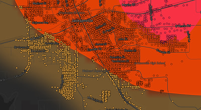
See exactly what you get.
Explore the full Springdale, AR Strike Map free – hail track, address overlay, and CSV download. No account required.
Try the Free Demo →