Ivins, UT Hail Storm – August 2026
August 14, 2026 hail storm near Ivins, UT. Radar-confirmed hail track and contractor lead lists available.
Max Hail
2.36"2.33" est.
confirmed
Zones
8
NWS alerts
Radar
4,902
dual-pol hits
Spotter
1
field reports
NWS WARNING AREA · Ivins Metro · Aug 14, 2026
Intelligence Platform
StormSnipe Pro
$49/ mo
Cancel anytime · No contracts
›All 50 states
›No zone limits
›No per-event fees
Subscribe to Pro
Pro renews monthly until canceled · Cancel anytime in the billing portal
What's included
Instant delivery
Every storm published within hours of NOAA confirmation.
Interactive Strike Map
Full radar-confirmed hail track on an interactive map.
Address CSV export
Every affected residential address, export-ready.
Smart alerts
Notified when a storm hits your area. Set zones once.
Nationwide coverage
All 50 states. No zone restrictions. No geographic caps.
Live pipeline
NOAA NEXRAD processed and delivered 24/7.
Address data notice
Pro coverage in California, Vermont, and Oregon includes the confirmed hail track and Strike Map only — no address lists. State data-privacy law treats compiled address lists differently in those three states, so we exclude their addresses from extraction and delivery.
NWS WARNING AREAS · 8
This storm generated 8 NWS alert zones. Pro access covers the complete storm track and all addresses across every zone.
ZONE 1NWS UTC053
Ivins, UT
Dual-Pol Radar
3 addresses in warning area
Alert issued Fri, Aug 14 · 2:43 PM UTC
1.33"
confirmed
1"
est. (NWS)
ZONE 2NWS NVC003
Las Vegas, NV
Dual-Pol Radar
Alert issued Fri, Aug 14 · 7:23 PM UTC
2.5"
confirmed
1.34"
est. (NWS)
ZONE 3NWS NVC003
Caliente, NV
Dual-Pol Radar
Alert issued Fri, Aug 14 · 8:11 PM UTC
2.5"
confirmed
1.54"
est. (NWS)
ZONE 4NWS AZC015
White Hills, AZ
Dual-Pol Radar
108 addresses in warning area
Alert issued Fri, Aug 14 · 9:39 PM UTC
2.75"
confirmed
1.74"
est. (NWS)
ZONE 5NWS AZC015
Hackberry, AZ
Dual-Pol Radar
19 addresses in warning area
Alert issued Fri, Aug 14 · 10:36 PM UTC
3.25"
confirmed
1.78"
est. (NWS)
ZONE 6NWS NVC003
Moapa, NV
Dual-Pol Radar
Alert issued Fri, Aug 14 · 10:50 PM UTC
2"
confirmed
1.67"
est. (NWS)
ZONE 7NWS AZC015
Hackberry, AZ
Dual-Pol Radar
1 addresses in warning area
Alert issued Fri, Aug 14 · 11:14 PM UTC
3.25"
confirmed
2.33"
est. (NWS)
ZONE 8NWS AZC015
Dolan Springs, AZ
Dual-Pol Radar
207 addresses in warning area
Alert issued Sat, Aug 15 · 12:28 AM UTC
1.52"
confirmed
1"
est. (NWS)
Ivins, UT experienced a multi-zone hail event on August 14, 2026, peaking at 2.36 inches in diameter and moving from mid-morning into early evening. The storm concluded after multiple radar-detected hail alerts across the metro area.
What Happened
NWS issued eight hail alerts tied to this system. Alerts began in mid-morning and continued into early evening, with radar-detected hail reported at the following times:
- 8:43 AM MDT — radar-detected 1.00-inch hail
- 1:23 PM MDT — radar-detected 1.34-inch hail
- 2:11 PM MDT — radar-detected 1.54-inch hail
- 3:39 PM MDT — radar-detected 1.74-inch hail
- 4:36 PM MDT — radar-detected 1.78-inch hail
- 4:50 PM MDT — radar-detected 1.67-inch hail
- 5:14 PM MDT — radar-detected 2.33-inch hail
- 6:28 PM MDT — radar-detected 1.00-inch hail
Dual-polarization NEXRAD hail detection tracked the storm’s intensity increasing through the afternoon and peaking in the late-afternoon period. The event’s maximum measured hail size was 2.36 inches. The system is no longer active over the Ivins area.
Damage Assessment
Hail along the Ivins track ranged roughly from 1.0 to 2.36 inches, with the largest stones occurring in the late-afternoon portion of the event. Stones above 2.0 inches commonly cause denting and panel damage to vehicles in exposed parking, fracture asphalt shingle edges, strip shingle granules, and crack skylights or solar panel glass when impact angles are direct.
On-site inspections should prioritize areas beneath the late-afternoon radar track through Ivins neighborhoods. Photographic documentation with a visible scale and timestamps will help separate new impact marks from pre-existing wear. Water intrusion risk increases where shingle fracture or granule loss is evident; check attics, soffits, and ceilings for stains and wet insulation during the first 48 hours.
What Contractors Should Know
Triage inspections first for active leaks and safety hazards. Confirm structural access, remove loose debris, and document all findings with close-up and contextual photos. Measure representative hail stones where available and record their locations relative to street addresses. Apply temporary tarping only where immediate water entry threatens interior finishes and secure work with installation photos and a signed work order.
Prepare repair estimates distinguishing cosmetic panel dents from structural roof damage. For asphalt roofing, document granule loss, shingle mat delamination, and fractured tabs to support replacement recommendations. Inspect and test rooftop-mounted equipment and solar arrays for impact damage before repair or reattachment. Coordinate documented findings with property owners and insurers; preserve original photos and a timeline tied to the August 14, 2026 event.
Storm Details
- Start Date
- Friday, August 14, 2026
- Last Activity
- Friday, August 14, 2026
- Location
- Ivins, UT
- Warning Areas
- 8
- Dual-Pol Radar
- 4,902
- Spotter Reports
- 1
Preview Strike Map
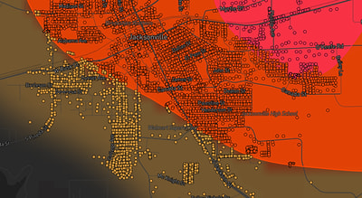
See exactly what you get.
Explore the full Springdale, AR Strike Map free – hail track, address overlay, and CSV download. No account required.
Try the Free Demo →