Hughesville, PA Hail Storm – September 2026
September 1, 2026 hail storm near Hughesville, PA. Radar-confirmed hail track and contractor lead lists available.
Max Hail
1.88"1.75" est.
confirmed
Zones
55
NWS alerts
Radar
1,406
dual-pol hits
Spotter
10
field reports
NWS WARNING AREA · Hughesville Metro · Sep 1, 2026
Intelligence Platform
StormSnipe Pro
$49/ mo
Cancel anytime · No contracts
›All 50 states
›No zone limits
›No per-event fees
Subscribe to Pro
Pro renews monthly until canceled · Cancel anytime in the billing portal
What's included
Instant delivery
Every storm published within hours of NOAA confirmation.
Interactive Strike Map
Full radar-confirmed hail track on an interactive map.
Address CSV export
Every affected residential address, export-ready.
Smart alerts
Notified when a storm hits your area. Set zones once.
Nationwide coverage
All 50 states. No zone restrictions. No geographic caps.
Live pipeline
NOAA NEXRAD processed and delivered 24/7.
Address data notice
Pro coverage in California, Vermont, and Oregon includes the confirmed hail track and Strike Map only — no address lists. State data-privacy law treats compiled address lists differently in those three states, so we exclude their addresses from extraction and delivery.
NWS WARNING AREAS · 55
This storm generated 55 NWS alert zones. Pro access covers the complete storm track and all addresses across every zone.
ZONE 1NWS PAC081
Hughesville, PA
Dual-Pol Radar
Alert issued Tue, Sep 1 · 8:26 PM UTC
2.75"
confirmed
1.25"
est. (NWS)
ZONE 2NWS PAC081
Roaring Branch, PA
Dual-Pol Radar
297 addresses in warning area
Alert issued Tue, Sep 1 · 8:51 PM UTC
2.75"
confirmed
1.5"
est. (NWS)
ZONE 3NWS NYC003
Wellsville, NY
Dual-Pol Radar
Alert issued Tue, Sep 1 · 9:02 PM UTC
1"
confirmed
1"
est. (NWS)
ZONE 4NWS PAC105
Ulysses, PA
Dual-Pol Radar
Alert issued Tue, Sep 1 · 9:04 PM UTC
2.25"
confirmed
1"
est. (NWS)
ZONE 5NWS PAC037
Catawissa, PA
Dual-Pol Radar
Alert issued Tue, Sep 1 · 9:10 PM UTC
2.25"
confirmed
1"
est. (NWS)
ZONE 6NWS PAC105
Sabinsville, PA
Dual-Pol Radar
193 addresses in warning area
Alert issued Tue, Sep 1 · 9:13 PM UTC
2.25"
confirmed
1.5"
est. (NWS)
ZONE 7NWS NYC101
Troupsburg, NY
Dual-Pol Radar
Alert issued Tue, Sep 1 · 9:17 PM UTC
1.25"
confirmed
1"
est. (NWS)
ZONE 8NWS PAC081
Roaring Branch, PA
Dual-Pol Radar
Alert issued Tue, Sep 1 · 9:19 PM UTC
2.75"
confirmed
1.75"
est. (NWS)
ZONE 9NWS PAC037
Muncy, PA
Dual-Pol Radar
Alert issued Tue, Sep 1 · 9:42 PM UTC
2.25"
confirmed
1.25"
est. (NWS)
ZONE 10NWS PAC081
Gaines, PA
Dual-Pol Radar
73 addresses in warning area
Alert issued Tue, Sep 1 · 9:42 PM UTC
2.25"
confirmed
1.35"
est. (NWS)
ZONE 11NWS NJC041
Cresco, PA
Dual-Pol Radar
Alert issued Tue, Sep 1 · 9:45 PM UTC
1.25"
confirmed
1"
est. (NWS)
ZONE 12NWS PAC037
Elysburg, PA
Dual-Pol Radar
Alert issued Tue, Sep 1 · 9:46 PM UTC
2.25"
confirmed
1.5"
est. (NWS)
ZONE 13NWS PAC079
White Haven, PA
Dual-Pol Radar
Alert issued Tue, Sep 1 · 9:49 PM UTC
1.25"
confirmed
1"
est. (NWS)
ZONE 14NWS PAC025
Weatherly, PA
Dual-Pol Radar
Alert issued Tue, Sep 1 · 9:50 PM UTC
1.25"
confirmed
1"
est. (NWS)
ZONE 15NWS PAC079
Shickshinny, PA
Dual-Pol Radar
Alert issued Tue, Sep 1 · 9:53 PM UTC
1.5"
confirmed
1"
est. (NWS)
ZONE 16NWS PAC039
Guys Mills, PA
Dual-Pol Radar
Alert issued Tue, Sep 1 · 10:01 PM UTC
1.25"
confirmed
1"
est. (NWS)
ZONE 17NWS PAC037
Pitman, PA
Dual-Pol Radar
Alert issued Tue, Sep 1 · 10:08 PM UTC
2.5"
confirmed
1"
est. (NWS)
ZONE 18NWS PAC011
Leesport, PA
Dual-Pol Radar
Alert issued Tue, Sep 1 · 10:09 PM UTC
1.75"
confirmed
1"
est. (NWS)
ZONE 19NWS NYC015
Troy, PA
Dual-Pol Radar
31 addresses in warning area
Alert issued Tue, Sep 1 · 10:14 PM UTC
1.75"
confirmed
1"
est. (NWS)
ZONE 20NWS PAC011
Womelsdorf, PA
Dual-Pol Radar
Alert issued Tue, Sep 1 · 10:21 PM UTC
2.5"
confirmed
1"
est. (NWS)
ZONE 21NWS NJC017
New York, NY
Dual-Pol Radar
Alert issued Tue, Sep 1 · 10:22 PM UTC
1"
confirmed
0.75"
est. (NWS)
ZONE 22NWS PAC025
Slatington, PA
Dual-Pol Radar
Alert issued Tue, Sep 1 · 10:29 PM UTC
2"
confirmed
1"
est. (NWS)
ZONE 23NWS PAC015
Granville Summit, PA
Dual-Pol Radar
Alert issued Tue, Sep 1 · 10:31 PM UTC
1.75"
confirmed
0.75"
est. (NWS)
ZONE 24NWS PAC075
Myerstown, PA
Dual-Pol Radar
Alert issued Tue, Sep 1 · 10:33 PM UTC
2.5"
confirmed
1.75"
est. (NWS)
ZONE 25NWS PAC069
Bear Creek, PA
Dual-Pol Radar
Alert issued Tue, Sep 1 · 10:40 PM UTC
1.25"
confirmed
1"
est. (NWS)
ZONE 26NWS PAC123
Clarendon, PA
Dual-Pol Radar
Alert issued Tue, Sep 1 · 10:42 PM UTC
1.5"
confirmed
1"
est. (NWS)
ZONE 27NWS NJC013
Mountainside, NJ
Dual-Pol Radar
1,894 addresses in warning area
Alert issued Tue, Sep 1 · 10:50 PM UTC
1.75"
confirmed
0.75"
est. (NWS)
ZONE 28NWS NJC023
Iselin, NJ
Dual-Pol Radar
19 addresses in warning area
Alert issued Tue, Sep 1 · 10:52 PM UTC
1.75"
confirmed
1"
est. (NWS)
ZONE 29NWS PAC011
Mohnton, PA
Dual-Pol Radar
Alert issued Tue, Sep 1 · 10:56 PM UTC
2.5"
confirmed
1"
est. (NWS)
ZONE 30NWS PAC015
New Albany, PA
Dual-Pol Radar
Alert issued Tue, Sep 1 · 10:58 PM UTC
1.5"
confirmed
1"
est. (NWS)
ZONE 31NWS PAC011
Womelsdorf, PA
Dual-Pol Radar
Alert issued Tue, Sep 1 · 10:58 PM UTC
2.5"
confirmed
1"
est. (NWS)
ZONE 32NWS NJC025
Atlantic Highlands, NJ
Dual-Pol Radar
Alert issued Tue, Sep 1 · 11:02 PM UTC
1.25"
confirmed
0.75"
est. (NWS)
ZONE 33NWS PAC113
Dushore, PA
Dual-Pol Radar
Alert issued Tue, Sep 1 · 11:07 PM UTC
1.5"
confirmed
1"
est. (NWS)
ZONE 34NWS PAC011
Bechtelsville, PA
Dual-Pol Radar
Alert issued Tue, Sep 1 · 11:13 PM UTC
2"
confirmed
1"
est. (NWS)
ZONE 35NWS PAC015
Ulster, PA
Dual-Pol Radar
Alert issued Tue, Sep 1 · 11:14 PM UTC
1.75"
confirmed
1"
est. (NWS)
ZONE 36NWS PAC047
Kane, PA
Dual-Pol Radar
Alert issued Tue, Sep 1 · 11:27 PM UTC
2.25"
confirmed
1"
est. (NWS)
ZONE 37NWS PAC113
Muncy Valley, PA
Dual-Pol Radar
Alert issued Tue, Sep 1 · 11:27 PM UTC
1.5"
confirmed
1.25"
est. (NWS)
ZONE 38NWS NJC023
South Amboy, NJ
Dual-Pol Radar
1,003 addresses in warning area
Alert issued Tue, Sep 1 · 11:28 PM UTC
1"
confirmed
1"
est. (NWS)
ZONE 39NWS PAC071
Gap, PA
Dual-Pol Radar
Alert issued Tue, Sep 1 · 11:31 PM UTC
2.5"
confirmed
1.5"
est. (NWS)
ZONE 40NWS DEC003
Parkesburg, PA
Dual-Pol Radar
Alert issued Tue, Sep 1 · 11:43 PM UTC
2.5"
confirmed
1"
est. (NWS)
ZONE 41NWS PAC037
Berwick, PA
Dual-Pol Radar
Alert issued Tue, Sep 1 · 11:46 PM UTC
0.5"
confirmed
1.25"
est. (NWS)
ZONE 42NWS PAC071
Christiana, PA
Dual-Pol Radar
Alert issued Tue, Sep 1 · 11:59 PM UTC
2.5"
confirmed
0.92"
est. (NWS)
ZONE 43NWS NJC005
Monroe Township, NJ
Dual-Pol Radar
Alert issued Wed, Sep 2 · 12:08 AM UTC
1.5"
confirmed
1"
est. (NWS)
ZONE 44NWS DEC003
Newark, DE
Dual-Pol Radar
Alert issued Wed, Sep 2 · 12:17 AM UTC
1"
confirmed
1"
est. (NWS)
ZONE 45NWS MDC015
Elkton, MD
Dual-Pol Radar
Alert issued Wed, Sep 2 · 12:19 AM UTC
1"
confirmed
0.75"
est. (NWS)
ZONE 46NWS NJC001
Williamstown, NJ
Dual-Pol Radar
Alert issued Wed, Sep 2 · 12:26 AM UTC
1.25"
confirmed
1"
est. (NWS)
ZONE 47NWS DEC001
Greenwich, NJ
Dual-Pol Radar
Alert issued Wed, Sep 2 · 12:46 AM UTC
1.25"
confirmed
1"
est. (NWS)
ZONE 48NWS NJC007
Franklinville, NJ
Dual-Pol Radar
Alert issued Wed, Sep 2 · 12:57 AM UTC
1.25"
confirmed
1"
est. (NWS)
ZONE 49NWS MDC015
Chesapeake City, MD
Dual-Pol Radar
Alert issued Wed, Sep 2 · 12:59 AM UTC
1"
confirmed
0.75"
est. (NWS)
ZONE 50NWS NJC005
West Creek, NJ
Dual-Pol Radar
Alert issued Wed, Sep 2 · 1:04 AM UTC
1"
confirmed
1"
est. (NWS)
ZONE 51NWS NJC005
Lumberton, NJ
Dual-Pol Radar
Alert issued Wed, Sep 2 · 1:07 AM UTC
0.75"
confirmed
0.75"
est. (NWS)
ZONE 52NWS NJC005
Lumberton, NJ
Dual-Pol Radar
Alert issued Wed, Sep 2 · 1:16 AM UTC
1"
confirmed
0.75"
est. (NWS)
ZONE 53NWS NJC001
Galloway, NJ
Dual-Pol Radar
Alert issued Wed, Sep 2 · 1:33 AM UTC
0.5"
confirmed
0.75"
est. (NWS)
ZONE 54NWS DEC001
Magnolia, DE
Dual-Pol Radar
Alert issued Wed, Sep 2 · 1:40 AM UTC
1.2"
confirmed
0.75"
est. (NWS)
ZONE 55NWS NJC001
Atlantic, NJ
Dual-Pol Radar
Alert issued Wed, Sep 2 · 1:54 AM UTC
0.5"
confirmed
0.75"
est. (NWS)
A hail-producing thunderstorm tracked through Hughesville, PA on September 1, 2026, producing 1.88-inch stones as it moved across the area in the late afternoon into the evening. The event generated 54 NWS alerts and a series of spotter and mPING reports concentrated near Williamstown.
What Happened
NWS alerts for this storm began at 4:26 PM EDT and continued through 9:54 PM EDT, covering a roughly five-and-a-half-hour window of active cells across the Hughesville metro. Dual-polarization radar flagged multiple hail cores during the run, with several radar-detected hail signatures reported between the mid-afternoon alerts and the final advisories just before 10:00 PM. A mix of NWS warning-only messages and radar-detected hail alerts tracked the cells as they propagated across the region.
Spotter and public observations were concentrated in the Williamstown area in the early evening. At 8:28 PM EDT spotters reported quarter-size hail in Williamstown. Earlier submissions around 8:18 PM EDT included multiple mPING entries noting dime-size and half-inch stones. Those ground reports coincided with nearby radar-detected hail signatures and a sequence of NWS warnings that bracketed the same timeframe. Radar-detected hail alerts up to the late-evening period complemented the spotter reports, indicating repeated hail-producing updrafts moved through the same corridor.
Damage Assessment
Local storm reports and public submissions describe mainly pebble- to quarter-size accumulation across Williamstown and adjacent sections of Lycoming County. The three spotter-verified entries at 8:28 PM EDT all note quarter-size hail at the same location. Multiple mPING submissions near 8:18 PM EDT recorded dime- and half-inch stones. No Local Storm Report entries or observer submissions for this event documented structural failures, roof blowoffs, or vehicle total losses in the submitted records.
Radar-detected hail swaths align with the cluster of spotter reports, indicating pockets of stronger surface impact where radar cores passed overhead. Reported stone sizes and observer notes point to superficial surface effects in most submissions — vegetation bruising, chipped vehicle paint, and localized accumulation in low spots were the most commonly reported impacts in observer text. Where spotters reported only dime- to half-inch hail, submitted photos and remarks show limited shingle granule loss and isolated cosmetic damage rather than widespread structural compromise.
What Contractors Should Know
Focus initial inspections on Williamstown and the immediate corridor where spotter-verified hail was logged at 8:28 PM EDT and where multiple mPING submissions were received around 8:18 PM EDT. Start with a rapid visual check for granule loss and nail pops on residential roofs, then inspect metal trim, gutters, and exposed HVAC housings for dents. Document all findings with time-stamped photos and GPS-referenced notes tied to the specific addresses or parcels you visit.
Storm Details
- Start Date
- Tuesday, September 1, 2026
- Last Activity
- Tuesday, September 1, 2026
- Location
- Hughesville, PA
- Warning Areas
- 55
- Dual-Pol Radar
- 1,406
- Spotter Reports
- 10
Preview Strike Map
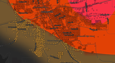
See exactly what you get.
Explore the full Springdale, AR Strike Map free – hail track, address overlay, and CSV download. No account required.
Try the Free Demo →