Cuba, NM Hail Storm – October 2026
October 23, 2026 hail storm near Cuba, NM. Radar-confirmed hail track and contractor lead lists available.
Max Hail
2.51"2.11" est.
confirmed
Zones
12
NWS alerts
Radar
3,114
dual-pol hits
Spotter
7
field reports
NWS WARNING AREA · Cuba Metro · Oct 23, 2026
Intelligence Platform
StormSnipe Pro
$49/ mo
Cancel anytime · No contracts
›All 50 states
›No zone limits
›No per-event fees
Subscribe to Pro
Pro renews monthly until canceled · Cancel anytime in the billing portal
What's included
Instant delivery
Every storm published within hours of NOAA confirmation.
Interactive Strike Map
Full radar-confirmed hail track on an interactive map.
Address CSV export
Every affected residential address, export-ready.
Smart alerts
Notified when a storm hits your area. Set zones once.
Nationwide coverage
All 50 states. No zone restrictions. No geographic caps.
Live pipeline
NOAA NEXRAD processed and delivered 24/7.
Address data notice
Pro coverage in California, Vermont, and Oregon includes the confirmed hail track and Strike Map only — no address lists. State data-privacy law treats compiled address lists differently in those three states, so we exclude their addresses from extraction and delivery.
NWS WARNING AREAS · 12
This storm generated 12 NWS alert zones. Pro access covers the complete storm track and all addresses across every zone.
ZONE 1NWS NMC039
Chama, NM
Dual-Pol Radar
Alert issued Fri, Oct 23 · 7:11 PM UTC
0.81"
confirmed
1"
est. (NWS)
ZONE 2NWS NMC039
Cuba, NM
Dual-Pol Radar
34 addresses in warning area
Alert issued Fri, Oct 23 · 8:02 PM UTC
1.52"
confirmed
1"
est. (NWS)
ZONE 3NWS NMC006
Cubero, NM
Dual-Pol Radar
99 addresses in warning area
Alert issued Fri, Oct 23 · 8:41 PM UTC
1.57"
confirmed
1"
est. (NWS)
ZONE 4NWS NMC043
Cuba, NM
Dual-Pol Radar
2 addresses in warning area
Alert issued Fri, Oct 23 · 8:44 PM UTC
1"
confirmed
1.06"
est. (NWS)
ZONE 5NWS NMC039
Cuba, NM
Spotter Reported
337 addresses in warning area
Alert issued Fri, Oct 23 · 9:16 PM UTC
0.88"
confirmed
1.5"
est. (NWS)
ZONE 6NWS NMC043
Rio Rancho, NM
Dual-Pol Radar
Alert issued Fri, Oct 23 · 9:28 PM UTC
1.28"
confirmed
2.11"
est. (NWS)
ZONE 7NWS NMC001
Albuquerque, NM
Dual-Pol Radar
Alert issued Fri, Oct 23 · 9:47 PM UTC
1.04"
confirmed
1.41"
est. (NWS)
ZONE 8NWS NMC053
Bosque, NM
Dual-Pol Radar
Alert issued Fri, Oct 23 · 9:56 PM UTC
1.57"
confirmed
1.24"
est. (NWS)
ZONE 9NWS NMC039
Youngsville, NM
Dual-Pol Radar
1 addresses in warning area
Alert issued Fri, Oct 23 · 9:57 PM UTC
0.5"
confirmed
1"
est. (NWS)
ZONE 10NWS NMC043
Jemez Pueblo, NM
Dual-Pol Radar
11 addresses in warning area
Alert issued Fri, Oct 23 · 10:09 PM UTC
1"
confirmed
1.67"
est. (NWS)
ZONE 11NWS NMC028
Los Alamos, NM
Dual-Pol Radar
51 addresses in warning area
Alert issued Fri, Oct 23 · 11:25 PM UTC
2.02"
confirmed
1.35"
est. (NWS)
ZONE 12NWS NMC028
Jemez Springs, NM
Dual-Pol Radar
Alert issued Sat, Oct 24 · 12:58 AM UTC
1.47"
confirmed
1.96"
est. (NWS)
Cuba, NM experienced a hail-producing thunderstorm on October 23, 2026, producing a maximum confirmed hail size of 2.02 inches and a multi-alert radar hail track across the local warning area.
What Happened
The event began with an NWS-issued severe thunderstorm warning at 1:11 PM MDT for 1.00-inch hail. Dual-polarization NEXRAD hail detections began shortly after and produced a series of 11 additional alerts between 2:02 PM and 6:58 PM MDT. Radar-derived hail estimates rose through mid- to late afternoon, with radar indicating sizes above 2 inches around 3:28 PM MDT. The hail-producing updrafts persisted into the early evening, with a near-2-inch radar detection recorded just before 7:00 PM MDT. The sequence totaled 12 alerts covering the NWS warning area and ended later that night. Most alerts were based on dual-polarization radar hail detection; the initial alert was NWS warning only.
Damage Assessment
Radar-detected hail spanned roughly 1.0–2.0+ inches along the hail track within the Cuba warning area. Hail in the 1.0–1.5 inch range commonly causes localized denting to vehicles and surface abrasion to asphalt shingles. Hail at or above 1.5 inches increases the risk of shingle bruising and shingle-edge damage on standard three-tab roofing. Hail approaching 2 inches can produce deeper dents in aluminum or soft-metal siding, dents in vehicle body panels, and can fracture skylights or thin single-pane glass in exposed locations.
Properties with older shingles, loose flashing, exposed HVAC condensers, or rooftop solar installations are at elevated risk along the radar-indicated track. Driveway, patio furniture, and unprotected vehicles parked under trees or carports within the warning area are most likely to show visible impact damage. Any observed roof granule loss, punctures, or rooftop glass damage noted in Cuba should be documented with time-stamped photos and kept separate from preexisting wear evidence.
What Contractors Should Know
Prioritize a rapid exterior survey for clients within the NWS warning area. Inspect asphalt shingles for granule loss, bruising, and fractured tabs. Check metal roofs and siding for dents. Record HVAC unit dents, condenser fin damage, and any compromised skylights or solar panels. Use high-resolution photos with timestamps and note exact addresses inside the issued warning polygon. Estimate likely scope changes for roofs older than 10 years and for properties showing concentrated damage along the radar hail track.
For immediate response use temporary tarps where shingles are penetrated or seams are open. Provide written documentation for insurance submissions that ties observed damage to the Oct 23 hail event and the local NWS warning area. Prepare repair versus replacement estimates based on measured hail impact extent. Keep crews aware of ladder and roof safety protocols during wet conditions and debris removal. Maintain separate records for preexisting damage and new hail impacts.
Storm Details
- Start Date
- Friday, October 23, 2026
- Last Activity
- Friday, October 23, 2026
- Location
- Cuba, NM
- Warning Areas
- 12
- Dual-Pol Radar
- 3,114
- Spotter Reports
- 7
Preview Strike Map
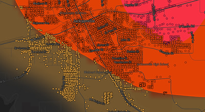
See exactly what you get.
Explore the full Springdale, AR Strike Map free – hail track, address overlay, and CSV download. No account required.
Try the Free Demo →