Columbus, NM Hail Storm – October 2026
October 23, 2026 hail storm near Columbus, NM. Radar-confirmed hail track and contractor lead lists available.
Max Hail
2.93"2.53" est.
confirmed
Zones
26
NWS alerts
Radar
12,679
dual-pol hits
Spotter
9
field reports
NWS WARNING AREA · Columbus Metro · Oct 23, 2026
Intelligence Platform
StormSnipe Pro
$49/ mo
Cancel anytime · No contracts
›All 50 states
›No zone limits
›No per-event fees
Subscribe to Pro
Pro renews monthly until canceled · Cancel anytime in the billing portal
What's included
Instant delivery
Every storm published within hours of NOAA confirmation.
Interactive Strike Map
Full radar-confirmed hail track on an interactive map.
Address CSV export
Every affected residential address, export-ready.
Smart alerts
Notified when a storm hits your area. Set zones once.
Nationwide coverage
All 50 states. No zone restrictions. No geographic caps.
Live pipeline
NOAA NEXRAD processed and delivered 24/7.
Address data notice
Pro coverage in California, Vermont, and Oregon includes the confirmed hail track and Strike Map only — no address lists. State data-privacy law treats compiled address lists differently in those three states, so we exclude their addresses from extraction and delivery.
NWS WARNING AREAS · 26
This storm generated 26 NWS alert zones. Pro access covers the complete storm track and all addresses across every zone.
ZONE 1NWS NMC017
Faywood, NM
Dual-Pol Radar
41 addresses in warning area
Alert issued Fri, Oct 23 · 9:20 PM UTC
1.81"
confirmed
1"
est. (NWS)
ZONE 2NWS NMC013
Columbus, NM
Dual-Pol Radar
Alert issued Fri, Oct 23 · 9:29 PM UTC
2"
confirmed
1.5"
est. (NWS)
ZONE 3NWS NMC017
Faywood, NM
NWS Warning
Alert issued Fri, Oct 23 · 9:46 PM UTC
1.81"
est. (NWS)
ZONE 4NWS NMC017
Mimbres, NM
Dual-Pol Radar
Alert issued Fri, Oct 23 · 9:48 PM UTC
1.51"
confirmed
1"
est. (NWS)
ZONE 5NWS NMC003
Datil, NM
Dual-Pol Radar
Alert issued Fri, Oct 23 · 9:49 PM UTC
0.92"
confirmed
1"
est. (NWS)
ZONE 6NWS NMC029
Columbus, NM
Dual-Pol Radar
1 addresses in warning area
Alert issued Fri, Oct 23 · 9:51 PM UTC
1.65"
confirmed
1.04"
est. (NWS)
ZONE 7NWS NMC017
Mimbres, NM
NWS Warning
Alert issued Fri, Oct 23 · 9:59 PM UTC
1.42"
est. (NWS)
ZONE 8NWS NMC017
Hillsboro, NM
Dual-Pol Radar
9 addresses in warning area
Alert issued Fri, Oct 23 · 10:07 PM UTC
2.93"
confirmed
1.26"
est. (NWS)
ZONE 9NWS NMC013
Columbus, NM
Dual-Pol Radar
Alert issued Fri, Oct 23 · 10:09 PM UTC
1.3"
confirmed
1.22"
est. (NWS)
ZONE 10NWS NMC029
Columbus, NM
Dual-Pol Radar
8 addresses in warning area
Alert issued Fri, Oct 23 · 10:12 PM UTC
1.59"
confirmed
1"
est. (NWS)
ZONE 11NWS NMC013
Deming, NM
Dual-Pol Radar
46 addresses in warning area
Alert issued Fri, Oct 23 · 10:27 PM UTC
1.63"
confirmed
1.12"
est. (NWS)
ZONE 12NWS NMC029
Columbus, NM
Dual-Pol Radar
5 addresses in warning area
Alert issued Fri, Oct 23 · 10:35 PM UTC
1.41"
confirmed
1.5"
est. (NWS)
ZONE 13NWS NMC013
Arrey, NM
Dual-Pol Radar
488 addresses in warning area
Alert issued Fri, Oct 23 · 10:41 PM UTC
2.66"
confirmed
2.53"
est. (NWS)
ZONE 14NWS NMC013
Las Cruces, NM
Dual-Pol Radar
4 addresses in warning area
Alert issued Fri, Oct 23 · 10:44 PM UTC
1.45"
confirmed
1.75"
est. (NWS)
ZONE 15NWS NMC029
Deming, NM
Dual-Pol Radar
48 addresses in warning area
Alert issued Fri, Oct 23 · 10:54 PM UTC
1.61"
confirmed
1.5"
est. (NWS)
ZONE 16NWS NMC013
Hatch, NM
Dual-Pol Radar
Alert issued Fri, Oct 23 · 11:09 PM UTC
0.98"
confirmed
1"
est. (NWS)
ZONE 17NWS NMC051
Truth or Consequences, NM
Dual-Pol Radar
2 addresses in warning area
Alert issued Fri, Oct 23 · 11:25 PM UTC
0.92"
confirmed
1.78"
est. (NWS)
ZONE 18NWS NMC029
Deming, NM
Dual-Pol Radar
Alert issued Fri, Oct 23 · 11:28 PM UTC
0.83"
confirmed
1.5"
est. (NWS)
ZONE 19NWS NMC051
Truth or Consequences, NM
Dual-Pol Radar
1 addresses in warning area
Alert issued Fri, Oct 23 · 11:28 PM UTC
1.41"
confirmed
1.12"
est. (NWS)
ZONE 20NWS NMC035
Orogrande, NM
Dual-Pol Radar
Alert issued Fri, Oct 23 · 11:30 PM UTC
1.68"
confirmed
1.27"
est. (NWS)
ZONE 21NWS NMC013
El Paso, TX
Dual-Pol Radar
26,570 addresses in warning area
Alert issued Fri, Oct 23 · 11:34 PM UTC
2.85"
confirmed
1.25"
est. (NWS)
ZONE 22NWS NMC051
Truth or Consequences, NM
Dual-Pol Radar
Alert issued Fri, Oct 23 · 11:36 PM UTC
0.74"
confirmed
1.64"
est. (NWS)
ZONE 23NWS NMC035
Fort Bliss, TX
Dual-Pol Radar
770 addresses in warning area
Alert issued Sat, Oct 24 · 12:04 AM UTC
1.75"
confirmed
2.3"
est. (NWS)
ZONE 24NWS NMC035
Alamogordo, NM
Dual-Pol Radar
51 addresses in warning area
Alert issued Sat, Oct 24 · 12:06 AM UTC
1.15"
confirmed
1.39"
est. (NWS)
ZONE 25NWS TXC141
El Paso, TX
Dual-Pol Radar
Alert issued Sat, Oct 24 · 12:16 AM UTC
2.41"
confirmed
1"
est. (NWS)
ZONE 26NWS NMC035
Tularosa, NM
Dual-Pol Radar
Alert issued Sat, Oct 24 · 12:34 AM UTC
0.87"
confirmed
0.75"
est. (NWS)
A severe hail storm tracked through Columbus, NM on October 23, 2026, producing 2.93-inch stones and generating 26 NWS hail alerts late afternoon into early evening.
What Happened
The event began in the mid-afternoon and continued into the early evening. NWS hail alerts were first issued at 3:20 PM MDT and continued through a final notice at 6:34 PM MDT. Most alerts were based on dual-polarization radar detections. Several alerts were issued as NWS warning only notifications during periods of rapid storm evolution.
Radar-detected hail reports during the sequence ranged from approximately 0.75 inch to 2.53 inches. Notable radar detections occurred in the late afternoon, including a 2.53-inch radar-derived detection at 4:41 PM MDT and a 2.30-inch radar-derived detection near 6:04 PM MDT. The dual-polarization returns showed repeated hail cores as the storm tracked across the Columbus metro.
Surface observations were limited but specific. At 6:00 PM MDT spotters reported hail covering the ground in the Costco parking lot at Interstate 10 and Towbridge Dr., indicating quarter-sized stones at that location. The same spotter recorded heavy rainfall of 1.5 inches and wind gusts of 45 to 50 mph as the storm passed.
Damage Assessment
Field reports show localized ground coverage of hail at the Costco parking lot near Interstate 10 and Towbridge Dr. Spotters on site recorded quarter-sized hail at 6:00 PM MDT and measured 1.5 inches of rain during the event. The spotter also reported wind gusts to 45–50 mph concurrent with the hail.
No additional local storm reports from other Columbus neighborhoods were received in the immediate aftermath. Radar indicated larger hail aloft on multiple passes, but surface verification at the documented location was limited to quarter-sized stones. The heavy rainfall reported at the Costco site likely increased run-off in the parking area and may have caused pooling adjacent to curbs and drains.
Vehicle owners and commercial fleets parked at the reported Costco location should prioritize photographic documentation of dents and paint damage tied to the 6:00 PM MDT observation. Contractors conducting initial assessments should record the spotter time and place for each photographed impact to maintain a clear event timeline.
What Contractors Should Know
Start with a structured triage at the Costco parking lot at Interstate 10 and Towbridge Dr. Photograph every vehicle and structure with a measurable scale item in frame. For vehicles, capture hood, roof, trunk, and windshield close-ups. For building envelopes, check gutters, downspouts, and ground-level debris for shattered window glass or displaced metal. Note the spotter-observed quarter-sized hail when cataloging dent size and pattern.
Inspect roofing and rooftop equipment with a lift or drone. Look for hail-induced bruises, loss of granules on asphalt shingle roofs, and impact marks on metal panels and HVAC housings. Wind gusts of 45–50 mph reported at 6:00 PM MDT increase the likelihood of minor wind-related seam separation and loose flashing. Prioritize rooftop units, solar arrays, and exposed conduit runs for physical checks.
Storm Details
- Start Date
- Friday, October 23, 2026
- Last Activity
- Friday, October 23, 2026
- Location
- Columbus, NM
- Warning Areas
- 26
- Dual-Pol Radar
- 12,679
- Spotter Reports
- 9
Preview Strike Map
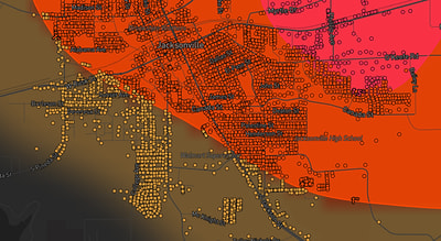
See exactly what you get.
Explore the full Springdale, AR Strike Map free – hail track, address overlay, and CSV download. No account required.
Try the Free Demo →