El Paso, TX Hail Storm – October 2026
October 24, 2026 hail storm near El Paso, TX. Radar-confirmed hail track and contractor lead lists available.
Max Hail
2.91"2" est.
confirmed
Zones
28
NWS alerts
Radar
16,905
dual-pol hits
Spotter
6
field reports
NWS WARNING AREA · El Paso Metro · Oct 24, 2026
Intelligence Platform
StormSnipe Pro
$49/ mo
Cancel anytime · No contracts
›All 50 states
›No zone limits
›No per-event fees
Subscribe to Pro
Pro renews monthly until canceled · Cancel anytime in the billing portal
What's included
Instant delivery
Every storm published within hours of NOAA confirmation.
Interactive Strike Map
Full radar-confirmed hail track on an interactive map.
Address CSV export
Every affected residential address, export-ready.
Smart alerts
Notified when a storm hits your area. Set zones once.
Nationwide coverage
All 50 states. No zone restrictions. No geographic caps.
Live pipeline
NOAA NEXRAD processed and delivered 24/7.
Address data notice
Pro coverage in California, Vermont, and Oregon includes the confirmed hail track and Strike Map only — no address lists. State data-privacy law treats compiled address lists differently in those three states, so we exclude their addresses from extraction and delivery.
NWS WARNING AREAS · 28
This storm generated 28 NWS alert zones. Pro access covers the complete storm track and all addresses across every zone.
ZONE 1NWS NMC035
Weed, NM
Dual-Pol Radar
Alert issued Sat, Oct 24 · 10:20 PM UTC
0.9"
confirmed
1.25"
est. (NWS)
ZONE 2NWS NMC013
El Paso, TX
Dual-Pol Radar
5,760 addresses in warning area
Alert issued Sat, Oct 24 · 10:24 PM UTC
1.49"
confirmed
1.25"
est. (NWS)
ZONE 3NWS NMC013
El Paso, TX
NWS Warning
201 addresses in warning area
Alert issued Sat, Oct 24 · 10:38 PM UTC
1.75"
est. (NWS)
ZONE 4NWS NMC013
Chaparral, NM
Dual-Pol Radar
Alert issued Sat, Oct 24 · 10:43 PM UTC
1.79"
confirmed
1.5"
est. (NWS)
ZONE 5NWS TXC141
Fabens, TX
Dual-Pol Radar
Alert issued Sat, Oct 24 · 10:47 PM UTC
1.83"
confirmed
1.25"
est. (NWS)
ZONE 6NWS NMC013
White Sands Missile Range, NM
Dual-Pol Radar
54 addresses in warning area
Alert issued Sat, Oct 24 · 10:52 PM UTC
1.92"
confirmed
1.25"
est. (NWS)
ZONE 7NWS TXC141
Fort Hancock, TX
Dual-Pol Radar
73 addresses in warning area
Alert issued Sat, Oct 24 · 10:59 PM UTC
2.41"
confirmed
1.75"
est. (NWS)
ZONE 8NWS NMC013
Anthony, NM
Dual-Pol Radar
1,712 addresses in warning area
Alert issued Sat, Oct 24 · 11:09 PM UTC
1"
confirmed
1.71"
est. (NWS)
ZONE 9NWS NMC013
Chaparral, NM
Dual-Pol Radar
Alert issued Sat, Oct 24 · 11:20 PM UTC
1.59"
confirmed
1.5"
est. (NWS)
ZONE 10NWS NMC035
Mayhill, NM
Dual-Pol Radar
Alert issued Sat, Oct 24 · 11:22 PM UTC
0.87"
confirmed
1"
est. (NWS)
ZONE 11NWS NMC013
Las Cruces, NM
Dual-Pol Radar
Alert issued Sat, Oct 24 · 11:36 PM UTC
1.92"
confirmed
1.5"
est. (NWS)
ZONE 12NWS TXC229
Fort Hancock, TX
Dual-Pol Radar
16 addresses in warning area
Alert issued Sat, Oct 24 · 11:39 PM UTC
2.86"
confirmed
2"
est. (NWS)
ZONE 13NWS NMC013
Orogrande, NM
Dual-Pol Radar
Alert issued Sat, Oct 24 · 11:53 PM UTC
1.61"
confirmed
1.36"
est. (NWS)
ZONE 14NWS NMC005
Flying H, NM
Dual-Pol Radar
1 addresses in warning area
Alert issued Sat, Oct 24 · 11:53 PM UTC
1.08"
confirmed
1"
est. (NWS)
ZONE 15NWS NMC051
Truth or Consequences, NM
Dual-Pol Radar
Alert issued Sat, Oct 24 · 11:55 PM UTC
1.76"
confirmed
1"
est. (NWS)
ZONE 16NWS NMC013
Organ, NM
Dual-Pol Radar
Alert issued Sun, Oct 25 · 12:02 AM UTC
1.92"
confirmed
1.92"
est. (NWS)
ZONE 17NWS NMC013
Truth or Consequences, NM
Dual-Pol Radar
Alert issued Sun, Oct 25 · 12:15 AM UTC
1.22"
confirmed
1.25"
est. (NWS)
ZONE 18NWS NMC027
Capitan, NM
Dual-Pol Radar
Alert issued Sun, Oct 25 · 12:17 AM UTC
0.91"
confirmed
1"
est. (NWS)
ZONE 19NWS NMC053
San Antonio, NM
Dual-Pol Radar
Alert issued Sun, Oct 25 · 12:28 AM UTC
1.34"
confirmed
1.25"
est. (NWS)
ZONE 20NWS NMC035
Tularosa, NM
Dual-Pol Radar
Alert issued Sun, Oct 25 · 12:34 AM UTC
0.81"
confirmed
0.75"
est. (NWS)
ZONE 21NWS NMC053
San Antonio, NM
Dual-Pol Radar
83 addresses in warning area
Alert issued Sun, Oct 25 · 12:57 AM UTC
1.45"
confirmed
1"
est. (NWS)
ZONE 22NWS TXC229
Fort Hancock, TX
Dual-Pol Radar
1 addresses in warning area
Alert issued Sun, Oct 25 · 1:04 AM UTC
2.91"
confirmed
1"
est. (NWS)
ZONE 23NWS NMC035
Salt Flat, TX
Dual-Pol Radar
15 addresses in warning area
Alert issued Sun, Oct 25 · 1:12 AM UTC
2.29"
confirmed
1.5"
est. (NWS)
ZONE 24NWS NMC013
Truth or Consequences, NM
Dual-Pol Radar
Alert issued Sun, Oct 25 · 1:24 AM UTC
0.91"
confirmed
1.5"
est. (NWS)
ZONE 25NWS NMC053
Socorro, NM
Dual-Pol Radar
Alert issued Sun, Oct 25 · 1:28 AM UTC
0.92"
confirmed
1"
est. (NWS)
ZONE 26NWS NMC035
Salt Flat, TX
Dual-Pol Radar
55 addresses in warning area
Alert issued Sun, Oct 25 · 1:50 AM UTC
1.69"
confirmed
1.08"
est. (NWS)
ZONE 27NWS NMC015
Carlsbad, NM
Dual-Pol Radar
15 addresses in warning area
Alert issued Sun, Oct 25 · 2:31 AM UTC
2.11"
confirmed
1"
est. (NWS)
ZONE 28NWS TXC229
Salt Flat, TX
Dual-Pol Radar
Alert issued Sun, Oct 25 · 4:48 AM UTC
1.85"
confirmed
1.34"
est. (NWS)
A hail-producing storm moved through El Paso, Texas, on October 24, 2026, producing stones up to 2.86 inches in diameter and generating 28 NWS alerts across the metro. The event ran from early evening into late night with repeated radar-detected hail signatures and one spotter-verified report.
What Happened
The episode began at 5:20 PM CDT with a radar-detected hail signature and continued as a series of cells crossing the El Paso metro. NWS alerts ran from 5:20 PM CDT to 11:48 PM CDT, totaling 28 separate notifications that alternated between radar-detected hail, NWS warning only notices, and mixed radar plus spotter verification. Early radar returns at 5:20 PM and 5:24 PM indicated roughly 1.25-inch hail; stronger returns near 5:38 PM and 5:59 PM showed growth to roughly 1.75 inches. A sequence of dual-polarization radar detections between 6:36 PM and 7:02 PM included signatures estimating up to roughly 2.0 inches and 1.92 inches. Several later radar detections continued to show 1.0–1.5-inch hail signatures through the late evening.
At 5:38 PM CDT a public report noted quarter-sized hail in the neighborhood near Rudy's, which was logged as a spotter-verified observation. That local report aligns with radar returns in the same time window and location. Several of the NWS alerts during the event were issued as warning-only notices; others were generated from dual-polarization radar detection and a subset included both radar and spotter verification.
Damage Assessment
Field reports remain limited. The only ground-truth entry from local storm observers on October 24 was a public report of quarter-sized hail near Rudy's at 5:38 PM CDT. No additional local storm reports documented structural failures, widespread vehicle damage, or large-scale tree injury in the metropolitan area in the immediate aftermath. Radar-detected hail signatures indicate stronger hail potential along portions of the track where 1.5-inch and larger echoes returned, but those radar footprints did not translate into multiple spotter-verified damage reports in the available local storm report set.
Where damage evaluations are already under way, crews should prioritize properties and assets within the NWS warning areas issued during the 5:20 PM to 11:48 PM window. Specific streets and neighborhoods near the Rudy's report location should receive early attention for cosmetic shingle bruising, dents to parked vehicles, and possible damage to exposed rooftop equipment. Document condition with time-stamped photos and note whether vehicles were parked outdoors during the early evening period.
What Contractors Should Know
Inspect roofs along the radar-indicated hail swath and within the NWS warning areas first. Focus inspections on asphalt shingles for granule loss, bruising, and split tabs; check metal panels and rooftop HVAC housings for dents and punctures. In this event, the most credible ground report was quarter-sized hail near Rudy's at 5:38 PM CDT, but radar signatures indicate larger hail potential elsewhere along the track. Prioritize properties that report visible damage or have vehicles that were left outside during the event.
Storm Details
- Start Date
- Saturday, October 24, 2026
- Last Activity
- Saturday, October 24, 2026
- Location
- El Paso, TX
- Warning Areas
- 28
- Dual-Pol Radar
- 16,905
- Spotter Reports
- 6
Preview Strike Map
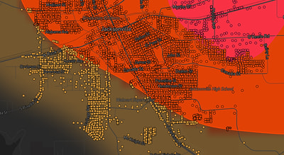
See exactly what you get.
Explore the full Springdale, AR Strike Map free – hail track, address overlay, and CSV download. No account required.
Try the Free Demo →