Chaparral, NM Hail Storm – October 2026
October 25, 2026 hail storm near Chaparral, NM. Radar-confirmed hail track and contractor lead lists available.
Max Hail
2.91"1.74" est.
confirmed
Zones
14
NWS alerts
Radar
4,954
dual-pol hits
Spotter
–
field reports
NWS WARNING AREA · Chaparral Metro · Oct 25, 2026
Intelligence Platform
StormSnipe Pro
$49/ mo
Cancel anytime · No contracts
›All 50 states
›No zone limits
›No per-event fees
Subscribe to Pro
Pro renews monthly until canceled · Cancel anytime in the billing portal
What's included
Instant delivery
Every storm published within hours of NOAA confirmation.
Interactive Strike Map
Full radar-confirmed hail track on an interactive map.
Address CSV export
Every affected residential address, export-ready.
Smart alerts
Notified when a storm hits your area. Set zones once.
Nationwide coverage
All 50 states. No zone restrictions. No geographic caps.
Live pipeline
NOAA NEXRAD processed and delivered 24/7.
Address data notice
Pro coverage in California, Vermont, and Oregon includes the confirmed hail track and Strike Map only — no address lists. State data-privacy law treats compiled address lists differently in those three states, so we exclude their addresses from extraction and delivery.
NWS WARNING AREAS · 14
This storm generated 14 NWS alert zones. Pro access covers the complete storm track and all addresses across every zone.
ZONE 1NWS NMC035
Chaparral, NM
Dual-Pol Radar
Alert issued Sun, Oct 25 · 10:40 PM UTC
2.22"
confirmed
1.1"
est. (NWS)
ZONE 2NWS TXC229
Fort Hancock, TX
NWS Warning
5 addresses in warning area
Alert issued Mon, Oct 26 · 12:42 AM UTC
1.28"
est. (NWS)
ZONE 3NWS TXC141
El Paso, TX
Dual-Pol Radar
464 addresses in warning area
Alert issued Mon, Oct 26 · 2:31 AM UTC
1.63"
confirmed
1"
est. (NWS)
ZONE 4NWS TXC141
Clint, TX
Dual-Pol Radar
2,251 addresses in warning area
Alert issued Mon, Oct 26 · 2:45 AM UTC
1.8"
confirmed
1"
est. (NWS)
ZONE 5NWS NMC035
Chaparral, NM
Dual-Pol Radar
Alert issued Mon, Oct 26 · 2:56 AM UTC
0.83"
confirmed
1.09"
est. (NWS)
ZONE 6NWS TXC141
El Paso, TX
Dual-Pol Radar
1,245 addresses in warning area
Alert issued Mon, Oct 26 · 3:06 AM UTC
1.67"
confirmed
1.67"
est. (NWS)
ZONE 7NWS NMC035
Piñon, NM
Dual-Pol Radar
Alert issued Mon, Oct 26 · 3:29 AM UTC
1.33"
confirmed
1"
est. (NWS)
ZONE 8NWS TXC141
El Paso, TX
Dual-Pol Radar
1,324 addresses in warning area
Alert issued Mon, Oct 26 · 3:32 AM UTC
0.57"
confirmed
1"
est. (NWS)
ZONE 9NWS TXC141
El Paso, TX
Dual-Pol Radar
Alert issued Mon, Oct 26 · 3:58 AM UTC
1.63"
confirmed
1.74"
est. (NWS)
ZONE 10NWS TXC141
El Paso, TX
NWS Warning
Alert issued Mon, Oct 26 · 4:24 AM UTC
1.52"
est. (NWS)
ZONE 11NWS TXC141
El Paso, TX
Dual-Pol Radar
2 addresses in warning area
Alert issued Mon, Oct 26 · 4:37 AM UTC
1.17"
confirmed
1.52"
est. (NWS)
ZONE 12NWS TXC229
El Paso, TX
Dual-Pol Radar
Alert issued Mon, Oct 26 · 4:46 AM UTC
1"
confirmed
1"
est. (NWS)
ZONE 13NWS TXC229
Salt Flat, TX
Dual-Pol Radar
Alert issued Mon, Oct 26 · 5:08 AM UTC
1.71"
confirmed
0.75"
est. (NWS)
ZONE 14NWS TXC141
Socorro, TX
NWS Warning
Alert issued Mon, Oct 26 · 6:03 AM UTC
1.02"
est. (NWS)
Chaparral, NM experienced a hail-producing thunderstorm on October 25, 2026, with a peak hail measurement of 2.22 inches and a multi-alert radar signature. The event produced repeated NWS alerts and a sustained radar-detected hail track across the Chaparral area.
What Happened
The storm initiated in the late afternoon and continued into the early morning hours. NWS issued 14 related alerts for the Chaparral area between 4:40 PM MDT and 12:03 AM MDT. Early radar detections began at 4:40 PM MDT with a 1.10-inch hail indication. Multiple dual-polarization radar detections followed through the evening, including notable radar returns indicating hail sizes near or above 1.5 inches at several times. One NWS alert in the sequence was issued as a warning-only entry without a concurrent dual-polarization radar detection. The final alert associated with the system occurred at 12:03 AM MDT on October 26 with a radar-detected 1.02-inch signature.
Radar coverage remained consistent across the event window. The alert cadence shows repeated radar-detected hail signatures across the same corridor east and southeast of central Chaparral. Several alerts recorded sub-2.0-inch signatures, including 1.67 inches at 9:06 PM MDT and 1.74 inches at 9:58 PM MDT, indicating the storm produced multiple cycles of significant hail growth as it moved through the metro area.
Damage Assessment
Radar-detected hail sizes during the event ranged from 0.75 inch to multiple detections in the 1.5–1.8 inch band. Hail in this measured band is consistent with vehicle panel dents, cracked or missing asphalt shingles, and damage to soft-sided exterior materials. The late-evening cluster of radar detections that included 1.52-inch and larger returns aligns with the period when the storm tracked over more densely populated pockets of Chaparral.
The presence of a warning-only alert in the sequence indicates at least one period where the NWS prioritized the public warning before a corresponding radar hail signature was fully resolved. Local ground surveys or spotter reports would be required to attribute specific structural or vehicle damage to particular alerts in the sequence. No spotter-verified damage reports are included in the radar alert set for this event.
What Contractors Should Know
Inspect roofs and vehicles in the east and southeast portions of Chaparral first. Radar-detected returns above 1.5 inches clustered in that corridor during late evening. Expect common asphalt shingle replacement needs, dented metal panels, and broken skylights or solar panels where installations were exposed. Document pre-existing conditions with photos and timestamps before repairs.
Prioritize replacement of roofing elements with visible penetration or granule loss. Use impact-resistant materials where code and budget allow. For vehicle repair operations, triage by panel severity and prioritize fleet or commercial vehicles that support emergency services. Coordinate with property owners to collect any available ground photos or insurance claims tied to the October 25 evening timeframe.
Storm Details
- Start Date
- Sunday, October 25, 2026
- Last Activity
- Monday, October 26, 2026
- Location
- Chaparral, NM
- Warning Areas
- 14
- Dual-Pol Radar
- 4,954
- Spotter Reports
- --
Preview Strike Map
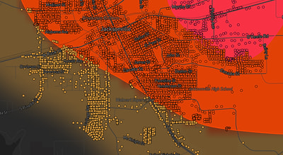
See exactly what you get.
Explore the full Springdale, AR Strike Map free – hail track, address overlay, and CSV download. No account required.
Try the Free Demo →