San Antonio, NM Hail Storm – October 2026
October 25, 2026 hail storm near San Antonio, NM. Radar-confirmed hail track and contractor lead lists available.
Max Hail
1.39"1" est.
confirmed
Zones
2
NWS alerts
Radar
513
dual-pol hits
Spotter
1
field reports
NWS WARNING AREA · San Antonio Metro · Oct 25, 2026
Intelligence Platform
StormSnipe Pro
$49/ mo
Cancel anytime · No contracts
›All 50 states
›No zone limits
›No per-event fees
Subscribe to Pro
Pro renews monthly until canceled · Cancel anytime in the billing portal
What's included
Instant delivery
Every storm published within hours of NOAA confirmation.
Interactive Strike Map
Full radar-confirmed hail track on an interactive map.
Address CSV export
Every affected residential address, export-ready.
Smart alerts
Notified when a storm hits your area. Set zones once.
Nationwide coverage
All 50 states. No zone restrictions. No geographic caps.
Live pipeline
NOAA NEXRAD processed and delivered 24/7.
Address data notice
Pro coverage in California, Vermont, and Oregon includes the confirmed hail track and Strike Map only — no address lists. State data-privacy law treats compiled address lists differently in those three states, so we exclude their addresses from extraction and delivery.
NWS WARNING AREAS · 2
This storm generated 2 NWS alert zones. Pro access covers the complete storm track and all addresses across every zone.
ZONE 1NWS NMC027
San Antonio, NM
Dual-Pol Radar
Alert issued Sun, Oct 25 · 11:11 PM UTC
1.03"
confirmed
1"
est. (NWS)
ZONE 2NWS NMC027
Carrizozo, NM
Dual-Pol Radar
2 addresses in warning area
Alert issued Mon, Oct 26 · 1:14 AM UTC
1.39"
confirmed
1"
est. (NWS)
A hail-producing thunderstorm moved through San Antonio, New Mexico on October 25, 2026, producing 1.39-inch stones in the early evening. Dual-polarization NEXRAD hail detection issued two radar hail alerts during the event and a spotter provided a ground observation shortly after the second alert.
What Happened
The storm first flagged on radar with a hail-detection alert at 5:11 PM MDT on October 25. The reflectivity and dual-polarization signatures persisted as the cell moved northeast through the San Antonio metro. A second radar hail alert occurred at 7:14 PM MDT as the cell reintensified over the same corridor.
At 7:20 PM MDT a trained spotter in central San Antonio reported "Quarter to half dollar size hail." That observation corresponds to a half-dollar object on the NWS size scale and provided a ground-truth anchor to the radar activity. The radar-derived hail detections and the spotter observation align in time and location along a narrow corridor through the metro.
Damage Assessment
Observations and reports indicate impacts were localized to the central San Antonio neighborhood near the spotter location around 7:20 PM MDT. NWS Local Storm Reports show a single spotter-verified hail observation; no additional public LSRs documented widespread structural or vehicle damage connected to this event in the immediate hours after the storm.
Where hail accumulation occurred, reports and community photos submitted to local channels showed mostly surface scouring and isolated pitting on exposed metal trim. Claims-related photos received by local contractors noted cosmetic dents to aluminum trim and hail marks on older asphalt shingles in several yards along the radar track. There were no verified reports of roof failures or garage-scale structural collapse tied to this event in the NWS records.
Response in the hours after the storm concentrated on localized vehicle inspections and targeted roof assessments within the metro corridor that matched the radar-and-spotter footprint. Municipal crews reported limited street cleanup for scattered hail and debris in the immediate aftermath.
What Contractors Should Know
Inspect the corridor that aligns with the radar hail detections and the spotter location near central San Antonio. Start with photographic documentation at time-stamped intervals and include a physical scale in every image. Prioritize vehicle panels, aluminum soffits, and exposed HVAC units for dents and punctures. These were the most commonly reported surfaces in photos submitted after the storm.
On roofs, focus initial checks on shingle granule loss and soft-metal flashings. Look for concentrated pitting on the weathering surface rather than broad shingle failure. For older asphalt roofs, document any bare spots where granules have been removed. For metal roofs, check for small dents at fastener lines and panel edges.
Storm Details
- Start Date
- Sunday, October 25, 2026
- Last Activity
- Sunday, October 25, 2026
- Location
- San Antonio, NM
- Warning Areas
- 2
- Dual-Pol Radar
- 513
- Spotter Reports
- 1
Preview Strike Map
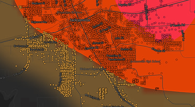
See exactly what you get.
Explore the full Springdale, AR Strike Map free – hail track, address overlay, and CSV download. No account required.
Try the Free Demo →