Picacho, NM Hail Storm – October 2026
October 25, 2026 hail storm near Picacho, NM. Radar-confirmed hail track and contractor lead lists available.
Max Hail
2.41"1.85" est.
confirmed
Zones
8
NWS alerts
Radar
3,244
dual-pol hits
Spotter
2
field reports
NWS WARNING AREA · Picacho Metro · Oct 25, 2026
Intelligence Platform
StormSnipe Pro
$49/ mo
Cancel anytime · No contracts
›All 50 states
›No zone limits
›No per-event fees
Subscribe to Pro
Pro renews monthly until canceled · Cancel anytime in the billing portal
What's included
Instant delivery
Every storm published within hours of NOAA confirmation.
Interactive Strike Map
Full radar-confirmed hail track on an interactive map.
Address CSV export
Every affected residential address, export-ready.
Smart alerts
Notified when a storm hits your area. Set zones once.
Nationwide coverage
All 50 states. No zone restrictions. No geographic caps.
Live pipeline
NOAA NEXRAD processed and delivered 24/7.
Address data notice
Pro coverage in California, Vermont, and Oregon includes the confirmed hail track and Strike Map only — no address lists. State data-privacy law treats compiled address lists differently in those three states, so we exclude their addresses from extraction and delivery.
NWS WARNING AREAS · 8
This storm generated 8 NWS alert zones. Pro access covers the complete storm track and all addresses across every zone.
ZONE 1NWS NMC005
Roswell, NM
Dual-Pol Radar
Alert issued Sun, Oct 25 · 11:46 PM UTC
1.45"
confirmed
1"
est. (NWS)
ZONE 2NWS NMC005
Roswell, NM
NWS Warning
1,585 addresses in warning area
Alert issued Mon, Oct 26 · 12:21 AM UTC
1"
est. (NWS)
ZONE 3NWS NMC027
Picacho, NM
Dual-Pol Radar
1 addresses in warning area
Alert issued Mon, Oct 26 · 12:41 AM UTC
1.68"
confirmed
1"
est. (NWS)
ZONE 4NWS NMC005
Roswell, NM
Dual-Pol Radar
Alert issued Mon, Oct 26 · 1:57 AM UTC
0.76"
confirmed
1.25"
est. (NWS)
ZONE 5NWS NMC005
Roswell, NM
Dual-Pol Radar
8 addresses in warning area
Alert issued Mon, Oct 26 · 2:30 AM UTC
1.2"
confirmed
1"
est. (NWS)
ZONE 6NWS NMC015
Carlsbad, NM
Dual-Pol Radar
26 addresses in warning area
Alert issued Mon, Oct 26 · 2:38 AM UTC
2.41"
confirmed
1.85"
est. (NWS)
ZONE 7NWS NMC005
Roswell, NM
Dual-Pol Radar
194 addresses in warning area
Alert issued Mon, Oct 26 · 3:11 AM UTC
1.39"
confirmed
1.25"
est. (NWS)
ZONE 8NWS NMC005
Roswell, NM
NWS Warning
Alert issued Mon, Oct 26 · 4:13 AM UTC
1"
est. (NWS)
Picacho, NM experienced a multi-zone severe hail event on October 25, 2026, producing a peak radar-measured stone of 2.41 inches and a string of NWS alerts through the early evening and late evening hours. The storm is concluded.
What Happened
The storm moved through the Picacho metro area in the early to late evening. Eight distinct NWS alert messages were issued for the event. Several alerts were based on dual-polarization radar detections; others were NWS warning-only alerts triggered by observed storm structure and warnings.
Alert sequence (local times):
- October 25 · 5:46 PM MDT (23:46 UTC) – 1.00-inch hail – radar-detected via dual-polarization NEXRAD
- October 25 · 6:21 PM MDT (00:21 UTC) – 1.00-inch hail – NWS warning only
- October 25 · 6:41 PM MDT (00:41 UTC) – 1.00-inch hail – NWS warning only
- October 25 · 7:57 PM MDT (01:57 UTC) – 1.25-inch hail – radar-detected via dual-polarization NEXRAD
- October 25 · 8:30 PM MDT (02:30 UTC) – 1.00-inch hail – radar-detected via dual-polarization NEXRAD
- October 25 · 8:38 PM MDT (02:38 UTC) – 1.85-inch hail – radar-detected via dual-polarization NEXRAD
- October 25 · 9:11 PM MDT (03:11 UTC) – 1.25-inch hail – radar-detected via dual-polarization NEXRAD
- October 25 · 10:13 PM MDT (04:13 UTC) – 1.00-inch hail – radar-detected via dual-polarization NEXRAD
Radar detections and NWS warnings overlapped geographically across multiple zones in the Picacho metro. The alert pattern shows periods of sustained hail-producing convection with intermittent increases in hail size detected by dual-polarization radar.
Damage Assessment
Radar-derived hail sizes during the event ranged from 1.00 inch up to 2.41 inches. Stones at the lower end of that range commonly cause cosmetic and surface damage. Expect paint chips on vehicles, denting on unprotected metal surfaces, and punctured siding where impact points concentrate.
Stones approaching and exceeding roughly 1.75 inches are large enough to dent panels, crack skylights, and create localized shingle damage. At the largest measured size for this event, roof coverings with existing wear or loose granules are at higher risk for accelerated failure. Glass breakage is possible where roofing penetrations or skylights were directly exposed.
No public spotter reports are included in this summary. Field verification will determine which properties and roof systems actually sustained loss. Insurance adjusters and contractor teams should prioritize physical inspections in areas that were under radar-detected alerts between 7:57 PM and 9:11 PM MDT, when the largest radar-derived stones were indicated.
What Contractors Should Know
Inspect roofs first for granule loss, bruising, and broken shingles. Start with a visual ground survey, then use close-up photos from a ladder or drone to document impacts before any temporary repairs. Photograph vehicle panels, gutters, HVAC units, and skylights with dated metadata. Note the local alert times and the radar-detected hail sizes when filing estimates.
Storm Details
- Start Date
- Sunday, October 25, 2026
- Last Activity
- Sunday, October 25, 2026
- Location
- Picacho, NM
- Warning Areas
- 8
- Dual-Pol Radar
- 3,244
- Spotter Reports
- 2
Preview Strike Map
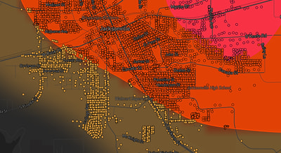
See exactly what you get.
Explore the full Springdale, AR Strike Map free – hail track, address overlay, and CSV download. No account required.
Try the Free Demo →