Phoenix, AZ Hail Storm – October 2026
October 30, 2026 hail storm near Phoenix, AZ. Radar-confirmed hail track and contractor lead lists available.
Max Hail
1.62"1.25" est.
confirmed
Zones
2
NWS alerts
Radar
554
dual-pol hits
Spotter
–
field reports
NWS WARNING AREA · Phoenix Metro · Oct 30, 2026
Intelligence Platform
StormSnipe Pro
$49/ mo
Cancel anytime · No contracts
›All 50 states
›No zone limits
›No per-event fees
Subscribe to Pro
Pro renews monthly until canceled · Cancel anytime in the billing portal
What's included
Instant delivery
Every storm published within hours of NOAA confirmation.
Interactive Strike Map
Full radar-confirmed hail track on an interactive map.
Address CSV export
Every affected residential address, export-ready.
Smart alerts
Notified when a storm hits your area. Set zones once.
Nationwide coverage
All 50 states. No zone restrictions. No geographic caps.
Live pipeline
NOAA NEXRAD processed and delivered 24/7.
Address data notice
Pro coverage in California, Vermont, and Oregon includes the confirmed hail track and Strike Map only — no address lists. State data-privacy law treats compiled address lists differently in those three states, so we exclude their addresses from extraction and delivery.
NWS WARNING AREAS · 2
This storm generated 2 NWS alert zones. Pro access covers the complete storm track and all addresses across every zone.
ZONE 1NWS AZC013
Phoenix, AZ
Dual-Pol Radar
5,204 addresses in warning area
Alert issued Fri, Oct 30 · 11:38 PM UTC
2.25"
confirmed
1"
est. (NWS)
ZONE 2NWS AZC013
Cave Creek, AZ
Dual-Pol Radar
Alert issued Sat, Oct 31 · 12:04 AM UTC
1.75"
confirmed
1.25"
est. (NWS)
Phoenix, AZ saw late-afternoon hail on October 30, 2026, with peak stones measuring 1.62 inches. The multi-zone metro storm prompted NWS warnings and radar hail detections before it concluded.
What Happened
The event moved through the Phoenix metro in late afternoon into early evening on October 30, 2026. The National Weather Service issued two alerts for the event. The first alert was issued at 4:38 PM MST (23:38 UTC) and cited 1.00-inch hail in the NWS warning only area. The second alert was issued at 5:04 PM MST (00:04 UTC) and reported 1.25-inch hail detected by dual-polarization radar (NEXRAD hail detection). Radar coverage and those sequential alerts defined the warning area across multiple zones of the metro. The storm status is concluded.
Damage Assessment
Hail in the 1.5-inch range commonly produces automotive dents, chipped glass, and localized roof damage in this market. Parked vehicles exposed during the late-afternoon period are at elevated risk for body panel dents and cracked outer glass. Tile and concrete roofing used widely across Phoenix can develop fractures or surface spalling when struck by stones approaching golf ball size. Asphalt shingle systems, particularly older installations with significant granule loss, are prone to torn tabs and accelerated wear after impacts of this magnitude.
Exterior equipment is also vulnerable. Photovoltaic panels can incur cracks in the glass layer. HVAC condenser coils and metal flashing may show fin and edge damage. Pool equipment and soft-surfaced coverings can sustain punctures or tears. Reported impacts to roofs and vehicles will vary by exposure, age of materials, and time parked or stored outdoors during the event.
What Contractors Should Know
Prioritize safe access and documented inspection. Start with a photographic perimeter survey of roofs, vehicles, and outdoor equipment. Capture dated, geotagged images when possible. Note material type and approximate age for each affected element. Preserve any broken shingles, tiles, or metal fragments for claims documentation. Use ladder and fall protection on sloped tile systems; fragile tile can break under foot traffic.
Estimate repair scope in two stages. Stage one is temporary mitigation to prevent interior water entry and further loss. Stage two is full repair or replacement based on material condition and warranty status. For customers with PV systems, coordinate with a qualified solar contractor before walking panels. Provide line-item estimates for granule loss, partial re-roof, and full replacement options. Confirm insurer expectations and adjust estimates for Phoenix-specific materials such as concrete tile and high-temperature-grade adhesives.
Paid users can view the radar-confirmed hail swath and damage zone on the Strike Map.
Storm Details
- Start Date
- Friday, October 30, 2026
- Last Activity
- Friday, October 30, 2026
- Location
- Phoenix, AZ
- Warning Areas
- 2
- Dual-Pol Radar
- 554
- Spotter Reports
- --
Preview Strike Map
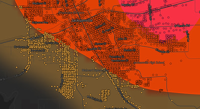
See exactly what you get.
Explore the full Springdale, AR Strike Map free – hail track, address overlay, and CSV download. No account required.
Try the Free Demo →