Truscott, TX Hail Storm – November 2026
November 2, 2026 hail storm near Truscott, TX. Radar-confirmed hail track and contractor lead lists available.
Max Hail
1.97"1.78" est.
confirmed
Zones
17
NWS alerts
Radar
979
dual-pol hits
Spotter
–
field reports
NWS WARNING AREA · Truscott Metro · Nov 2, 2026
Intelligence Platform
StormSnipe Pro
$49/ mo
Cancel anytime · No contracts
›All 50 states
›No zone limits
›No per-event fees
Subscribe to Pro
Pro renews monthly until canceled · Cancel anytime in the billing portal
What's included
Instant delivery
Every storm published within hours of NOAA confirmation.
Interactive Strike Map
Full radar-confirmed hail track on an interactive map.
Address CSV export
Every affected residential address, export-ready.
Smart alerts
Notified when a storm hits your area. Set zones once.
Nationwide coverage
All 50 states. No zone restrictions. No geographic caps.
Live pipeline
NOAA NEXRAD processed and delivered 24/7.
Address data notice
Pro coverage in California, Vermont, and Oregon includes the confirmed hail track and Strike Map only — no address lists. State data-privacy law treats compiled address lists differently in those three states, so we exclude their addresses from extraction and delivery.
NWS WARNING AREAS · 17
This storm generated 17 NWS alert zones. Pro access covers the complete storm track and all addresses across every zone.
ZONE 1NWS TXC023
Truscott, TX
Dual-Pol Radar
14 addresses in warning area
Alert issued Mon, Nov 2 · 9:44 PM UTC
2.25"
confirmed
1"
est. (NWS)
ZONE 2NWS TXC023
Vera, TX
Dual-Pol Radar
Alert issued Mon, Nov 2 · 10:18 PM UTC
2.25"
confirmed
1"
est. (NWS)
ZONE 3NWS TXC023
Electra, TX
Dual-Pol Radar
111 addresses in warning area
Alert issued Mon, Nov 2 · 10:22 PM UTC
3"
confirmed
1"
est. (NWS)
ZONE 4NWS OKC141
Davidson, OK
Dual-Pol Radar
Alert issued Mon, Nov 2 · 10:39 PM UTC
1"
confirmed
0.75"
est. (NWS)
ZONE 5NWS OKC065
Elmer, OK
Dual-Pol Radar
4 addresses in warning area
Alert issued Mon, Nov 2 · 10:46 PM UTC
0.32"
confirmed
1"
est. (NWS)
ZONE 6NWS OKC141
Electra, TX
Dual-Pol Radar
Alert issued Mon, Nov 2 · 10:53 PM UTC
3"
confirmed
1"
est. (NWS)
ZONE 7NWS OKC031
Grandfield, OK
Dual-Pol Radar
Alert issued Mon, Nov 2 · 11:24 PM UTC
2.5"
confirmed
1.78"
est. (NWS)
ZONE 8NWS OKC033
Burkburnett, TX
Dual-Pol Radar
90 addresses in warning area
Alert issued Mon, Nov 2 · 11:31 PM UTC
1.5"
confirmed
0.75"
est. (NWS)
ZONE 9NWS OKC033
Burkburnett, TX
Dual-Pol Radar
53 addresses in warning area
Alert issued Mon, Nov 2 · 11:59 PM UTC
1.5"
confirmed
0.75"
est. (NWS)
ZONE 10NWS OKC033
Randlett, OK
Dual-Pol Radar
Alert issued Tue, Nov 3 · 12:40 AM UTC
1.5"
confirmed
0.75"
est. (NWS)
ZONE 11NWS TXC009
Holliday, TX
NWS Warning
8 addresses in warning area
Alert issued Tue, Nov 3 · 1:21 AM UTC
1.43"
est. (NWS)
ZONE 12NWS OKC067
Waurika, OK
Dual-Pol Radar
Alert issued Tue, Nov 3 · 1:25 AM UTC
1.05"
confirmed
1"
est. (NWS)
ZONE 13NWS OKC067
Byers, TX
NWS Warning
Alert issued Tue, Nov 3 · 1:39 AM UTC
1"
est. (NWS)
ZONE 14NWS OKC067
Ryan, OK
NWS Warning
Alert issued Tue, Nov 3 · 2:11 AM UTC
0.75"
est. (NWS)
ZONE 15NWS OKC019
Ringling, OK
Dual-Pol Radar
5 addresses in warning area
Alert issued Tue, Nov 3 · 2:36 AM UTC
1.13"
confirmed
0.75"
est. (NWS)
ZONE 16NWS TXC337
Nocona, TX
NWS Warning
Alert issued Tue, Nov 3 · 2:52 AM UTC
1"
est. (NWS)
ZONE 17NWS OKC019
Burneyville, OK
NWS Warning
59 addresses in warning area
Alert issued Tue, Nov 3 · 3:30 AM UTC
0.75"
est. (NWS)
Truscott, TX — November 2, 2026: A multi-zone storm produced a peak hailstone of 1.97 inches and moved across the Truscott area from late afternoon into the early evening. The event generated a sequence of NWS warnings and radar hail detections before concluding after nightfall.
What Happened
Seventeen NWS alerts were issued for the Truscott metro area between 3:44 PM CST and 9:30 PM CST. The first NWS warning began at 3:44 PM CST. Most alerts carried "NWS warning only" designation. Two radar-detected hail signatures were reported in the NEXRAD dual-polarization record during the event: a 1.78-inch radar detection at 5:24 PM CST and a 1.43-inch radar detection at 7:21 PM CST. Additional NWS warning-only hail reports clustered in late afternoon and early evening, with repeated 1.00-inch and 0.75-inch advisory values punctuating the sequence.
The storm moved northeast through and beyond the Truscott metro area. The alert cadence shows sustained hail potential spanning roughly six hours from late afternoon into the first half of the evening. The event is listed as concluded.
Damage Assessment
Hail approached 2 inches in diameter, placing it in the upper golf-ball size range. Golf ball size is 1.75 inches by the NWS object scale. Hail of this class commonly produces dents to vehicle sheet metal, concentrated granule loss on asphalt shingles, and dimpling or punctures on exposed siding and non-impact-rated skylights.
Observed warning patterns and radar detections indicate the most significant hail intensity occurred in discrete swaths across rural and mixed-residential parcels north and northeast of central Truscott. Inspectors should prioritize vehicles parked outdoors, metal outbuildings, farm equipment, and the windward sides of structures along the storm track for visible denting, cracked glazing, and displaced shingle granules. Repeated smaller hail during the event can accelerate wear on older roofing materials.
What Contractors Should Know
Safety first. Confirm stable working conditions and local road access before mobilizing. When documenting losses, record GPS coordinates, time-stamped photos of roof planes and vehicle damage, and measurements that compare hail size to a standard object or ruler. Note the sequence of alerts and radar-detected hail signatures when preparing estimates – include the 5:24 PM CST and 7:21 PM CST radar detections as reference points for heavier-hail swaths.
For triage, inspect roofing edges, ridge caps, HVAC units, gutter faces, and protective coatings. Look for blown granules in gutters and on downspouts as a rapid indicator of granule loss. Apply temporary tarps only where necessary to prevent water intrusion and photograph tarp placement with a wide shot showing reference points. Deliver itemized scopes with before-and-after photos and precise locations to speed claims processing.
Storm Details
- Start Date
- Monday, November 2, 2026
- Last Activity
- Monday, November 2, 2026
- Location
- Truscott, TX
- Warning Areas
- 17
- Dual-Pol Radar
- 979
- Spotter Reports
- --
Preview Strike Map
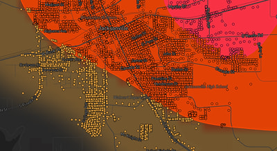
See exactly what you get.
Explore the full Springdale, AR Strike Map free – hail track, address overlay, and CSV download. No account required.
Try the Free Demo →