Wingate, TX Hail Storm – November 2026
November 2, 2026 hail storm near Wingate, TX. Radar-confirmed hail track and contractor lead lists available.
Max Hail
1.35"1" est.
confirmed
Zones
4
NWS alerts
Radar
26
dual-pol hits
Spotter
–
field reports
NWS WARNING AREA · Wingate Metro · Nov 3, 2026
Intelligence Platform
StormSnipe Pro
$49/ mo
Cancel anytime · No contracts
›All 50 states
›No zone limits
›No per-event fees
Subscribe to Pro
Pro renews monthly until canceled · Cancel anytime in the billing portal
What's included
Instant delivery
Every storm published within hours of NOAA confirmation.
Interactive Strike Map
Full radar-confirmed hail track on an interactive map.
Address CSV export
Every affected residential address, export-ready.
Smart alerts
Notified when a storm hits your area. Set zones once.
Nationwide coverage
All 50 states. No zone restrictions. No geographic caps.
Live pipeline
NOAA NEXRAD processed and delivered 24/7.
Address data notice
Pro coverage in California, Vermont, and Oregon includes the confirmed hail track and Strike Map only — no address lists. State data-privacy law treats compiled address lists differently in those three states, so we exclude their addresses from extraction and delivery.
NWS WARNING AREAS · 4
This storm generated 4 NWS alert zones. Pro access covers the complete storm track and all addresses across every zone.
ZONE 1NWS TXC353
Maryneal, TX
Dual-Pol Radar
Alert issued Tue, Nov 3 · 12:01 AM UTC
1.5"
confirmed
1"
est. (NWS)
ZONE 2NWS TXC081
Wingate, TX
Dual-Pol Radar
1 addresses in warning area
Alert issued Tue, Nov 3 · 12:52 AM UTC
1.09"
confirmed
1"
est. (NWS)
ZONE 3NWS TXC083
Coleman, TX
Dual-Pol Radar
22 addresses in warning area
Alert issued Tue, Nov 3 · 2:29 AM UTC
1.35"
confirmed
1"
est. (NWS)
ZONE 4NWS TXC093
Gorman, TX
NWS Warning
37 addresses in warning area
Alert issued Tue, Nov 3 · 3:46 AM UTC
1"
est. (NWS)
Wingate, TX – November 2, 2026. A concluded early-evening thunderstorm produced up to 1.35-inch hail across the Wingate metro in a multi-zone aggregate storm report.
What Happened
The event began in the early evening and progressed through late evening on November 2, 2026. The National Weather Service issued a warning area at 6:52 PM CST for 1.00-inch hail. At 8:29 PM CST, dual-polarization NEXRAD radar detected 1.00-inch hail signatures over parts of the metro. A second NWS warning area was issued at 9:46 PM CST for 1.00-inch hail. Storm status is concluded.
Maximum hail size for the aggregate report was 1.35 inches. The alert sequence includes two NWS warning-area issuances and one radar-detected hail report. The radar detection at 8:29 PM CST provided independent evidence of hail in the corridor between the two warning areas. No spotter-verified hail sizes are included in the alert set for this multi-zone report.
Damage Assessment
Observed and detected hail sizes ranged from 1.00 inch to 1.35 inches. A 1.00-inch object corresponds to a U.S. quarter. A 1.35-inch stone is larger than a quarter but smaller than a golf ball (1.75 inches). Hail in this size range commonly produces localized impact to exposed surfaces along its path through Wingate.
Specific risks for properties in the warning area included dents to vehicle sheet metal, bruising or granule loss on asphalt shingles that are already weathered, and damage to vulnerable exterior fixtures such as skylights and exposed glazing. Ground-level landscaping and soft coverings showed signs of impact in similar events of this size. No field reports of catastrophic structural failure are included with the alert sequence for this event.
What Contractors Should Know
Prioritize visual roof and exterior inspections in the NWS warning areas issued on November 2. Check for bruised shingles, displaced flashings, dented gutters, and dented metal panels on vehicles. Document findings with dated photographs showing scale and location. Record the local time of inspection. Limit initial access to safe surfaces and follow standard ladder and fall-protection procedures.
For claims and repairs, advise property owners to contact insurers promptly and to retain damaged materials for review. Temporary tarping is appropriate for active leaks; secure permits and follow local codes for removal and replacement. Coordinate scheduling around documented radar detection times when possible. Paid subscribers can access the Strike Map to view the radar-confirmed damage zone and hail swath for this event.
Storm Details
- Start Date
- Monday, November 2, 2026
- Last Activity
- Monday, November 2, 2026
- Location
- Wingate, TX
- Warning Areas
- 4
- Dual-Pol Radar
- 26
- Spotter Reports
- --
Preview Strike Map
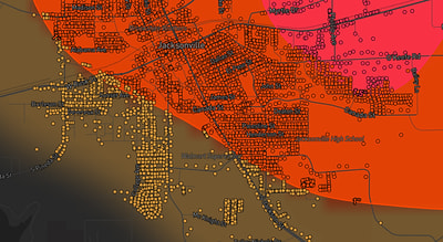
See exactly what you get.
Explore the full Springdale, AR Strike Map free – hail track, address overlay, and CSV download. No account required.
Try the Free Demo →