Crossville, IL Hail Storm – November 2026
November 11, 2026 hail storm near Crossville, IL. Radar-confirmed hail track and contractor lead lists available.
Max Hail
2.1"1.25" est.
confirmed
Zones
17
NWS alerts
Radar
6,195
dual-pol hits
Spotter
59
field reports
NWS WARNING AREA · Crossville Metro · Nov 11, 2026
Intelligence Platform
StormSnipe Pro
$49/ mo
Cancel anytime · No contracts
›All 50 states
›No zone limits
›No per-event fees
Subscribe to Pro
Pro renews monthly until canceled · Cancel anytime in the billing portal
What's included
Instant delivery
Every storm published within hours of NOAA confirmation.
Interactive Strike Map
Full radar-confirmed hail track on an interactive map.
Address CSV export
Every affected residential address, export-ready.
Smart alerts
Notified when a storm hits your area. Set zones once.
Nationwide coverage
All 50 states. No zone restrictions. No geographic caps.
Live pipeline
NOAA NEXRAD processed and delivered 24/7.
Address data notice
Pro coverage in California, Vermont, and Oregon includes the confirmed hail track and Strike Map only — no address lists. State data-privacy law treats compiled address lists differently in those three states, so we exclude their addresses from extraction and delivery.
NWS WARNING AREAS · 17
This storm generated 17 NWS alert zones. Pro access covers the complete storm track and all addresses across every zone.
ZONE 1NWS ILC047
Crossville, IL
Dual-Pol Radar
116 addresses in warning area
Alert issued Wed, Nov 11 · 9:56 PM UTC
2.25"
confirmed
1"
est. (NWS)
ZONE 2NWS INC167
Terre Haute, IN
Dual-Pol Radar
936 addresses in warning area
Alert issued Wed, Nov 11 · 9:56 PM UTC
2"
confirmed
1"
est. (NWS)
ZONE 3NWS ILC023
Marshall, IL
Dual-Pol Radar
54 addresses in warning area
Alert issued Wed, Nov 11 · 9:57 PM UTC
1.5"
confirmed
1.01"
est. (NWS)
ZONE 4NWS INC051
Patoka, IN
Dual-Pol Radar
Alert issued Wed, Nov 11 · 10:10 PM UTC
1"
confirmed
1"
est. (NWS)
ZONE 5NWS INC021
Centerpoint, IN
Dual-Pol Radar
135 addresses in warning area
Alert issued Wed, Nov 11 · 10:23 PM UTC
2"
confirmed
1.25"
est. (NWS)
ZONE 6NWS INC021
Cory, IN
Dual-Pol Radar
114 addresses in warning area
Alert issued Wed, Nov 11 · 10:27 PM UTC
2"
confirmed
1.2"
est. (NWS)
ZONE 7NWS INC051
Evansville, IN
Dual-Pol Radar
5 addresses in warning area
Alert issued Wed, Nov 11 · 10:43 PM UTC
1.25"
confirmed
1"
est. (NWS)
ZONE 8NWS INC051
Petersburg, IN
Dual-Pol Radar
Alert issued Wed, Nov 11 · 10:51 PM UTC
1.25"
confirmed
1"
est. (NWS)
ZONE 9NWS INC025
Eckerty, IN
Dual-Pol Radar
Alert issued Wed, Nov 11 · 11:12 PM UTC
1.25"
confirmed
1"
est. (NWS)
ZONE 10NWS INC109
Martinsville, IN
Dual-Pol Radar
53 addresses in warning area
Alert issued Wed, Nov 11 · 11:16 PM UTC
1.5"
confirmed
1"
est. (NWS)
ZONE 11NWS INC147
Grandview, IN
Dual-Pol Radar
Alert issued Wed, Nov 11 · 11:25 PM UTC
1.25"
confirmed
1"
est. (NWS)
ZONE 12NWS INC147
Maceo, KY
Dual-Pol Radar
Alert issued Thu, Nov 12 · 12:04 AM UTC
1.25"
confirmed
1"
est. (NWS)
ZONE 13NWS KYC059
Sebree, KY
Dual-Pol Radar
15 addresses in warning area
Alert issued Thu, Nov 12 · 12:16 AM UTC
1.15"
confirmed
1"
est. (NWS)
ZONE 14NWS INC147
Lewisport, KY
Dual-Pol Radar
Alert issued Thu, Nov 12 · 12:45 AM UTC
1.25"
confirmed
1"
est. (NWS)
ZONE 15NWS INC123
Cloverport, KY
Dual-Pol Radar
9 addresses in warning area
Alert issued Thu, Nov 12 · 12:51 AM UTC
1.5"
confirmed
1"
est. (NWS)
ZONE 16NWS KYC091
Hawesville, KY
Dual-Pol Radar
Alert issued Thu, Nov 12 · 12:56 AM UTC
1.5"
confirmed
1.18"
est. (NWS)
ZONE 17NWS KYC009
Cave City, KY
Dual-Pol Radar
15 addresses in warning area
Alert issued Thu, Nov 12 · 2:51 AM UTC
1.25"
confirmed
1"
est. (NWS)
A severe hail storm tracked through Crossville, Illinois on November 11, 2026, producing 2.1-inch stones and multiple spotter-verified reports in the late afternoon and early evening. The National Weather Service issued a sequence of alerts covering the warning area as the storm moved northeast across local roads and communities.
What Happened
The event began in mid-afternoon and progressed into early evening. NWS issued the first alert at 3:56 PM CST; that initial advisory was NWS warning only for 1.00-inch hail at the leading edge of the storm. Dual-polarization radar detected repeated hail signatures through the afternoon with follow-up radar alerts issued at 3:56 PM, 3:57 PM, 4:10 PM, and later intervals. Radar and spotter-verified messages were exchanged during the 4:20–6:00 PM window as cells tracked northeast.
Field observations were concentrated along a corridor from Patoka through North Posey and portions of the SR 261 corridor. At 4:29 PM CST, three spotter-verified reports recorded golf ball-sized hail at the same timestamp. Social media and media-relayed videos from around 4:20 PM and 5:10 PM documented dime-to-quarter-size hail in Patoka and mixed quarter-size pieces at North Posey High School. Residents at SR 261 and Rose Hill Drive reported heavy coverage of dime-to-quarter-sized hail that damaged a vehicle. Additional spotter reports between 4:49 PM and 6:24 PM described quarter-sized accumulations across neighborhood streets.
The alert sequence totaled 17 NWS advisories for the warning area. Some were radar-detected only. Several later alerts combined radar detection with spotter verification, including messages near 5:25 PM and 6:45 PM that matched local observer reports. The storm concluded after the final radar-based alert at 8:51 PM CST.
Damage Assessment
Field reports indicate localized vehicle damage and widespread quarter-size accumulation across residential streets near SR 261, Rose Hill Drive, and North Posey High School. Media-relayed video shows mixed-quarter-size hail on school grounds at approximately 5:10 PM CST. Multiple residents reported vehicle dents at SR 261 and Rose Hill Drive where hail reportedly covered the ground. Three spotter reports timestamped 4:29 PM CST documented larger stones in a concentrated area, which aligns with the localized pattern of more severe impact.
No specific commercial property losses were reported in the collected ground-truth feeds. Damage descriptions are concentrated on vehicle panels and exposed outdoor assets along the documented corridor. Observers described dime-to-quarter accumulations leaving ground coverage in Patoka around 4:20 PM CST and repeated quarter-size reports through early evening near populated streets. Those on-site accounts correspond with radar-detected hail signatures that persisted intermittently through the 6:00 PM hour.
Inspectors arriving from the northeast side of Crossville should expect variability in impact over short distances. Some addresses reported only scattered dime-size impacts, while nearby locations recorded quarter-size coverage and vehicle damage. Documented reports and radar matches are clustered along the Patoka–North Posey–SR 261 corridor rather than uniformly across the full NWS warning area.
Storm Details
- Start Date
- Wednesday, November 11, 2026
- Last Activity
- Wednesday, November 11, 2026
- Location
- Crossville, IL
- Warning Areas
- 17
- Dual-Pol Radar
- 6,195
- Spotter Reports
- 59
Preview Strike Map
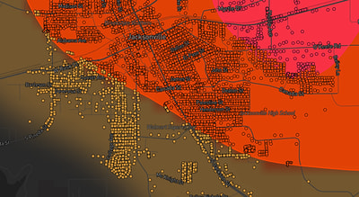
See exactly what you get.
Explore the full Springdale, AR Strike Map free – hail track, address overlay, and CSV download. No account required.
Try the Free Demo →