Whitethorn, CA Hail Storm – November 2026
November 13, 2026 hail storm near Whitethorn, CA. Radar-confirmed hail track and contractor lead lists available.
Max Hail
0.54"1" est.
confirmed
Zones
2
NWS alerts
Radar
2
dual-pol hits
Spotter
5
field reports
NWS WARNING AREA · Whitethorn Metro · Nov 13, 2026
Intelligence Platform
StormSnipe Pro
$49/ mo
Cancel anytime · No contracts
›All 50 states
›No zone limits
›No per-event fees
Subscribe to Pro
Pro renews monthly until canceled · Cancel anytime in the billing portal
What's included
Instant delivery
Every storm published within hours of NOAA confirmation.
Interactive Strike Map
Full radar-confirmed hail track on an interactive map.
Address CSV export
Every affected residential address, export-ready.
Smart alerts
Notified when a storm hits your area. Set zones once.
Nationwide coverage
All 50 states. No zone restrictions. No geographic caps.
Live pipeline
NOAA NEXRAD processed and delivered 24/7.
Address data notice
Pro coverage in California, Vermont, and Oregon includes the confirmed hail track and Strike Map only — no address lists. State data-privacy law treats compiled address lists differently in those three states, so we exclude their addresses from extraction and delivery.
NWS WARNING AREAS · 2
This storm generated 2 NWS alert zones. Pro access covers the complete storm track and all addresses across every zone.
ZONE 1NWS CAC023
Whitethorn, CA
Dual-Pol Radar
Alert issued Fri, Nov 13 · 8:53 PM UTC
2"
confirmed
1"
est. (NWS)
ZONE 2NWS CAC023
Trinidad, CA
NWS Warning
Alert issued Fri, Nov 13 · 9:24 PM UTC
1"
est. (NWS)
A hail storm moved through Whitethorn, CA on November 13, 2026, producing stones up to 2.0 inches and a mix of radar-detected swaths and spotter-verified impacts along the coastal corridor.
What Happened
Dual-polarization radar produced an early detection at 12:53 PM PST (20:53 UTC) indicating 1.00-inch hail in the warning area. The National Weather Service issued a severe thunderstorm warning at 1:24 PM PST (21:24 UTC) that referenced 1.00-inch hail but did not have an accompanying radar detection at that moment.
Spotter and public reports tracked the storm path along the Shelter Cove coastline into nearby inland pockets. At 12:54 PM PST (20:54 UTC) observers near Shelter Cove estimated half dollar-sized hail, about 1.25 inches. Roughly six minutes later, at 1:00 PM PST (21:00 UTC), a public report near Black Sands Beach in Shelter Cove described hen egg-sized hail; that observation was spotter-verified. Later in the afternoon, at 2:20 PM PST (22:20 UTC) spotters reported pea-sized hail roughly 4 miles south of Honeydew, and at 3:15 PM PST (23:15 UTC) another public report recorded quarter-sized hail along the coastal margin.
Radar-detected swaths and the sequence of spotter reports indicate a concentrated corridor of stronger hail returns near Shelter Cove with weakening cells as the line moved inland toward Honeydew. The mix of radar detections and on-the-ground observations established the timing and spatial progression used in the post-event analysis.
Damage Assessment
Field reports show the heaviest impacts concentrated on the Shelter Cove shoreline and immediate inland approaches. Spotters at Black Sands Beach and adjacent Shelter Cove locations documented the largest stones and reported localized hard impacts to exposed surfaces. Public observations south of Honeydew registered only small, pea-size impacts.
No source reports included structural collapse or widespread catastrophic failures. Localized risks tied to the larger stones include panel dents on parked vehicles and damage to unprotected glazing or exposed solar arrays in the Shelter Cove area. Vegetation along the coastal fringe near Black Sands Beach is more likely to show shredded leaves or broken branches where observers recorded larger stones.
The timing of the larger stones — centered near midday into early afternoon — combined with coastal exposure increases the chance that vehicles and rooftop systems were hit while residents were outdoors or parked near the shore. Field reports did not include quantified estimates of insured loss. Use the spotter times and locations above when documenting damage for claims or contractual assessments.
What Contractors Should Know
Prioritize inspections in Shelter Cove, starting with the Black Sands Beach corridor and nearby residential blocks where spotters recorded the largest stones around midday. Begin with exterior roofing surfaces, solar panel arrays, and parked vehicles. Look for shallow dents on metal panels, fractured glazing, and concentrated point impacts that match 1.25- to 2.0-inch stone signatures.
Storm Details
- Start Date
- Friday, November 13, 2026
- Last Activity
- Friday, November 13, 2026
- Location
- Whitethorn, CA
- Warning Areas
- 2
- Dual-Pol Radar
- 2
- Spotter Reports
- 5
Preview Strike Map
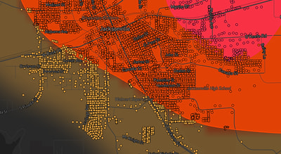
See exactly what you get.
Explore the full Springdale, AR Strike Map free – hail track, address overlay, and CSV download. No account required.
Try the Free Demo →