Piñon, NM Hail Storm – November 2026
November 13, 2026 hail storm near Piñon, NM. Radar-confirmed hail track and contractor lead lists available.
Max Hail
1.44"1.24" est.
confirmed
Zones
1
NWS alerts
Radar
82
dual-pol hits
Spotter
–
field reports
NWS WARNING AREA · Piñon Metro · Nov 14, 2026
Intelligence Platform
StormSnipe Pro
$49/ mo
Cancel anytime · No contracts
›All 50 states
›No zone limits
›No per-event fees
Subscribe to Pro
Pro renews monthly until canceled · Cancel anytime in the billing portal
What's included
Instant delivery
Every storm published within hours of NOAA confirmation.
Interactive Strike Map
Full radar-confirmed hail track on an interactive map.
Address CSV export
Every affected residential address, export-ready.
Smart alerts
Notified when a storm hits your area. Set zones once.
Nationwide coverage
All 50 states. No zone restrictions. No geographic caps.
Live pipeline
NOAA NEXRAD processed and delivered 24/7.
Address data notice
Pro coverage in California, Vermont, and Oregon includes the confirmed hail track and Strike Map only — no address lists. State data-privacy law treats compiled address lists differently in those three states, so we exclude their addresses from extraction and delivery.
NWS WARNING AREA
NWS NMC035
Piñon, NM
Dual-Pol Radar
Alert issued Sat, Nov 14 · 5:02 AM UTC
1.25"
confirmed
1.24"
est. (NWS)
Piñon, NM — November 13, 2026 — A late-evening thunderstorm produced radar-detected hail that peaked at 1.24 inches and triggered a single NWS severe thunderstorm warning. The event was brief and concentrated across the Piñon warning area.
What Happened
The storm moved over Piñon during the late evening, prompting one NWS warning issued at 10:02 PM MST (05:02 UTC). Dual-polarization NEXRAD hail detection identified a focused hail track associated with the warned cell. The alert covered the town-sized warning area and closed shortly after issuance as the cell weakened. There were no additional NWS alerts tied to this storm.
Radar returns showed a compact hail signature aligned with the warning area. The detection came from operational dual-polarization radar processing and was delivered as a single-event hail detection for the local warning polygon. Ground reports or spotter-submitted damage tied to this event were not recorded in the warning area during the evening hours.
Damage Assessment
Hail at this diameter can produce vehicle panel dents, break or chip exposed glass in some cases, and abrade painted surfaces and vinyl siding where exposures are unshielded. Roof coverings with existing wear or older asphalt shingles are more likely to show granule loss and localized bruising under this level of impact. Late-evening timing increased exposure for parked vehicles and outdoor equipment left unsecured near residences and small businesses in town.
No verified field damage reports were recorded within the NWS warning area during or immediately after the event. Claims and repair needs should be based on post-storm inspections of the specific addresses in the warning area rather than on the warning polygon alone.
What Contractors Should Know
Inspect roofs, siding, and vehicle panels for signs consistent with the identified hail track. Focus initial fieldwork on properties that faced the storm’s approach direction and on platforms where vehicles were likely parked overnight. Document all findings with date-stamped photos showing scale and orientation. Prioritize temporary protection and water-entry prevention if roofing defects or broken skylights are found.
Prepare scopes that separate impact-related material loss from age-related degradation. Note granule loss patterns, punctures, and dent depth when estimating repairs. For late-evening events, schedule exterior inspections during daylight and plan for elevated-surface safety measures. Use the Strike Map product to review the radar-confirmed hail swath and the paid damage zone for precise planning and allocation of field resources.
Storm Details
- Start Date
- Friday, November 13, 2026
- Last Activity
- Friday, November 13, 2026
- Location
- Piñon, NM
- Warning Areas
- 1
- Dual-Pol Radar
- 82
- Spotter Reports
- --
Preview Strike Map
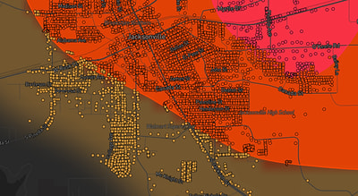
See exactly what you get.
Explore the full Springdale, AR Strike Map free – hail track, address overlay, and CSV download. No account required.
Try the Free Demo →