Littlefield, TX Hail Storm – November 2026
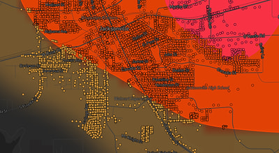
November 14, 2026 hail storm near Littlefield, TX. Radar-confirmed hail track and contractor lead lists available.
Max Hail
1.09"1" est.
confirmed
Zones
1
NWS alerts
Radar
862
dual-pol hits
Spotter
–
field reports
NWS WARNING AREA · Littlefield Metro · Nov 14, 2026
Intelligence Platform
StormSnipe Pro
$49/ mo
Cancel anytime · No contracts
›All 50 states
›No zone limits
›No per-event fees
Subscribe to Pro
Pro renews monthly until canceled · Cancel anytime in the billing portal
What's included
Instant delivery
Every storm published within hours of NOAA confirmation.
Interactive Strike Map
Full radar-confirmed hail track on an interactive map.
Address CSV export
Every affected residential address, export-ready.
Smart alerts
Notified when a storm hits your area. Set zones once.
Nationwide coverage
All 50 states. No zone restrictions. No geographic caps.
Live pipeline
NOAA NEXRAD processed and delivered 24/7.
Address data notice
Pro coverage in California, Vermont, and Oregon includes the confirmed hail track and Strike Map only — no address lists. State data-privacy law treats compiled address lists differently in those three states, so we exclude their addresses from extraction and delivery.
NWS WARNING AREA
NWS TXC219
Littlefield, TX
Dual-Pol Radar
Alert issued Sat, Nov 14 · 10:42 PM UTC
1"
confirmed
1"
est. (NWS)
Littlefield, TX experienced a late-afternoon severe thunderstorm on November 14, 2026. The event produced 1.00-inch hail and prompted an NWS severe thunderstorm warning at 4:42 PM CST (22:42 UTC).
What Happened
The storm moved through the Littlefield area in the late afternoon of November 14. The National Weather Service issued a severe thunderstorm warning at 4:42 PM CST (22:42 UTC) covering the single-zone area. The warning cited hail up to 1.00 inch and did not include spotter-verified damage reports attached to the alert. Radar signatures supported hail potential used in the warning issuance, while ground verification remained limited to reports collected after the warning.
The event is concluded. No subsequent NWS warnings were issued for this cell in the Littlefield zone after the 4:42 PM CST alert. Observers should note the short-lived nature of the storm and the narrow timing window during late afternoon when hail was indicated.
Damage Assessment
Quarter-sized hail can dent unprotected metal surfaces and dent vehicle body panels. It can chip or abrade vehicle paint and cause loss of roof shingle granules on older asphalt roofs. Skylights, greenhouse glazing, and exposed HVAC condenser fins are also vulnerable to quarter-sized impacts.
For this Littlefield event, the initial NWS warning did not contain spotter-verified damage entries. That indicates limited ground confirmation at the time of warning issuance. Claims and field inspections should therefore rely on documented photos, timestamps, and measured impact marks gathered after the storm rather than on a spotter-verified damage log tied to the warning itself.
What Contractors Should Know
Prioritize visual inspections of vehicles, roofing, siding, and exterior glass in the Littlefield area. Photograph impact points with a clear reference object and time stamp. Check for dent patterns on multiple vehicles or repeated granular loss on shingles to establish a consistent impact signature. Record notes on elevation and exposure for rooftop inspections and inspect rooftop-mounted equipment and condensers for bent fins or punctures.
Document temporary repairs and make conservative recommendations for permanent work. Use tarps or temporary covers where necessary to prevent water intrusion while arranging for full repairs. Provide itemized estimates that distinguish surface dents from structural or water-entry damage. Coordinate early with property owners and insurers and include measured impact samples and dated photos in any claim packet.
Refer to the Strike Map for the radar-confirmed hail swath for this event.
Storm Details
- Start Date
- Saturday, November 14, 2026
- Last Activity
- Saturday, November 14, 2026
- Location
- Littlefield, TX
- Warning Areas
- 1
- Dual-Pol Radar
- 862
- Spotter Reports
- --
Preview Strike Map
See exactly what you get.
Explore the full Springdale, AR Strike Map free – hail track, address overlay, and CSV download. No account required.
Try the Free Demo →