Colorado City, TX Hail Storm – November 2026
November 14, 2026 hail storm near Colorado City, TX. Radar-confirmed hail track and contractor lead lists available.
Max Hail
1.18"0.88" est.
confirmed
Zones
1
NWS alerts
Radar
623
dual-pol hits
Spotter
–
field reports
NWS WARNING AREA · Colorado City Metro · Nov 15, 2026
Intelligence Platform
StormSnipe Pro
$49/ mo
Cancel anytime · No contracts
›All 50 states
›No zone limits
›No per-event fees
Subscribe to Pro
Pro renews monthly until canceled · Cancel anytime in the billing portal
What's included
Instant delivery
Every storm published within hours of NOAA confirmation.
Interactive Strike Map
Full radar-confirmed hail track on an interactive map.
Address CSV export
Every affected residential address, export-ready.
Smart alerts
Notified when a storm hits your area. Set zones once.
Nationwide coverage
All 50 states. No zone restrictions. No geographic caps.
Live pipeline
NOAA NEXRAD processed and delivered 24/7.
Address data notice
Pro coverage in California, Vermont, and Oregon includes the confirmed hail track and Strike Map only — no address lists. State data-privacy law treats compiled address lists differently in those three states, so we exclude their addresses from extraction and delivery.
NWS WARNING AREA
NWS TXC335
Colorado City, TX
Dual-Pol Radar
2 addresses in warning area
Alert issued Sun, Nov 15 · 3:34 AM UTC
1.18"
confirmed
0.88"
est. (NWS)
Colorado City, Texas experienced a late-evening hail event on November 14, 2026, producing 1.18-inch hail and a compact, fast-moving hail core. The storm concluded the same night after prompting a single NWS warning.
What Happened
The line of convection reached the Colorado City area in the late evening hours on November 14. The National Weather Service issued one severe thunderstorm warning at 9:34 PM CST for 0.88-inch hail with NWS warning only confidence. Dual-polarization radar detected a concentrated hail core as the cell crossed the local warning area. No additional NWS alerts were issued for the same system after the 9:34 PM warning. The event was brief and localized within the single warning polygon covering the metro area.
Damage Assessment
Hail at this scale commonly dents unshielded vehicle panels, chips automotive paint, and leaves circular impact marks on aluminum and vinyl siding. Roofing materials with low remaining life, particularly three-tab asphalt shingles, are prone to granular loss and bruising that can accelerate leakage over the following months. Skylights, exposed HVAC condenser fins, and polycarbonate panels are vulnerable to punctures or cracks when impacted repeatedly.
Observed structural failure during similar late-evening, compact hail cores often appears as scattered hail hits rather than uniform coverage. Ground-level soft materials such as potted plants, outdoor furniture cushions, and thin solar panel covers are likely to show visible impact marks. Vehicle windshield breakage is less common at this size but remains possible on older or pre-damaged glass.
What Contractors Should Know
Prioritize a rapid exterior inspection of the north- and west-facing roof slopes first. Check for granule loss in roof valleys, bruises on asphalt shingles, and displaced flashing around roof penetrations. Photograph impact locations from multiple angles with a time-stamped camera or phone. Record GPS coordinates or clear location descriptors for each damaged asset. Inspect HVAC condensers and window glazing for dents and cracked fins. Separate obvious hail damage from pre-existing wear in documentation.
For temporary mitigation, secure tarps only when interior water entry is observed or imminent. Temporary tarps should be installed with breathable underlayment and documented with photos before work begins. Provide separate line items for hail-specific repairs versus general maintenance in estimates. Advise property owners to contact their insurer early and to retain vehicles for adjuster inspection where dents are present.
Order the Strike Map to view the radar-confirmed hail swath and to align field inspections with the radar-derived damage zone.
Storm Details
- Start Date
- Saturday, November 14, 2026
- Last Activity
- Saturday, November 14, 2026
- Location
- Colorado City, TX
- Warning Areas
- 1
- Dual-Pol Radar
- 623
- Spotter Reports
- --
Preview Strike Map
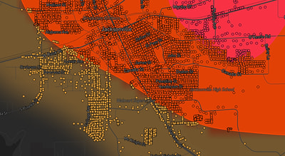
See exactly what you get.
Explore the full Springdale, AR Strike Map free – hail track, address overlay, and CSV download. No account required.
Try the Free Demo →