Bay City, TX Hail Storm – November 2026
November 15, 2026 hail storm near Bay City, TX. Radar-confirmed hail track and contractor lead lists available.
Max Hail
1.28"0.75" est.
confirmed
Zones
1
NWS alerts
Radar
20
dual-pol hits
Spotter
–
field reports
NWS WARNING AREA · Bay City Metro · Nov 15, 2026
Intelligence Platform
StormSnipe Pro
$49/ mo
Cancel anytime · No contracts
›All 50 states
›No zone limits
›No per-event fees
Subscribe to Pro
Pro renews monthly until canceled · Cancel anytime in the billing portal
What's included
Instant delivery
Every storm published within hours of NOAA confirmation.
Interactive Strike Map
Full radar-confirmed hail track on an interactive map.
Address CSV export
Every affected residential address, export-ready.
Smart alerts
Notified when a storm hits your area. Set zones once.
Nationwide coverage
All 50 states. No zone restrictions. No geographic caps.
Live pipeline
NOAA NEXRAD processed and delivered 24/7.
Address data notice
Pro coverage in California, Vermont, and Oregon includes the confirmed hail track and Strike Map only — no address lists. State data-privacy law treats compiled address lists differently in those three states, so we exclude their addresses from extraction and delivery.
NWS WARNING AREA
NWS TXC321
Bay City, TX
Dual-Pol Radar
Alert issued Sun, Nov 15 · 7:29 PM UTC
1.28"
confirmed
0.75"
est. (NWS)
Bay City, TX hail event — November 15, 2026
Bay City, TX experienced a hail-producing thunderstorm on November 15, 2026. The event produced up to 1.28 inches of hail and is concluded.
What Happened
A single storm cell moved through the Bay City metro during mid-afternoon on November 15. The National Weather Service issued one warning at 1:29 PM CST (19:29 UTC) that cited hail to 0.75 inch. That warning was issued as an NWS warning only alert.
Dual-polarization radar detected a concentrated hail core tracking across the immediate metro area. Radar-derived hail detections were used to map the storm's translational path. The storm weakened as it moved northeast and no additional NWS alerts were issued after the 1:29 PM warning. The event is no longer active.
Damage Assessment
Hail in the three-quarter-inch range through slightly above quarter-sized objects typically causes denting to vehicle body panels and can remove granules from asphalt shingles. For residential roofing, expect localized shingle granule loss, minor surface bruising on siding, and cosmetic dents on unprotected metal surfaces.
Glass breakage is uncommon at these sizes but can occur where hail was wind-driven into skylights, solar arrays, or exposed glazing. Soft metals such as aluminum trim and thin-gauge gutters are most susceptible to cosmetic and functional damage. Inspect for early signs of water infiltration at roof penetrations and around flashing.
What Contractors Should Know
Begin with a clear, documented inspection. Photograph roof fields, flashings, vents, gutter runs, and representative vehicle panels with a time stamp. Note granule loss patterns and any punctures or cracked sealants. Prioritize interior checks for staining or drips that indicate active leaks.
For short-term mitigation, apply temporary tarps and secure loose flashing to limit water entry before full repairs. Prepare scope assessments that separate cosmetic hail dents from structural or leak-related repairs. Coordinate with property owners on insurance documentation and provide concise line-item estimates. Maintain ladder and electrical safety protocols when working near power lines or wet surfaces.
Subscribers can view the radar-confirmed hail swath and damage zone in the Strike Map product.
Storm Details
- Start Date
- Sunday, November 15, 2026
- Last Activity
- Sunday, November 15, 2026
- Location
- Bay City, TX
- Warning Areas
- 1
- Dual-Pol Radar
- 20
- Spotter Reports
- --
Preview Strike Map
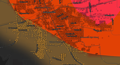
See exactly what you get.
Explore the full Springdale, AR Strike Map free – hail track, address overlay, and CSV download. No account required.
Try the Free Demo →